Click here for other railways.
Southampton to WokingThe London and Southampton Railway opened the route from London to Southampton in stages from 1838 to 1840. On preparing to serve Portsmouth it changed its name to the London and South Western Railway in June 1839. Its original termini, at Nine Elms in London and at Southampton Docks, proved inconvenient and the line was extended to better-situated main stations at both ends.
Southampton Central/West Station
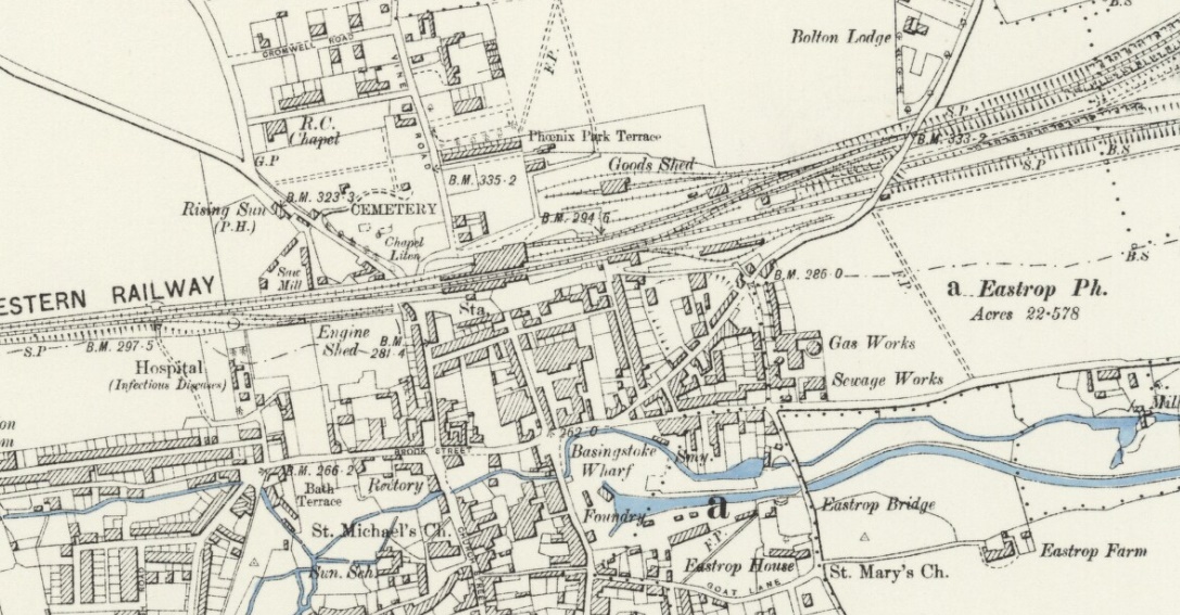
Southampton Central station was opened as Southampton West in 1895, to replace the original Blechynden/West End station. As built the station was on the seafront (specifically the stretch of water known as West Bay) with the water reaching right up to the southern edge of the platforms at high tide. A series of land reclamation projects to expand the docks, largely funded by the London and South Western Railway culminated in the building of the vast Western Docks between 1927 and 1934, which led to all of West Bay being reclaimed and the station becoming landlocked. The new land allowed the station to be enlarged and redeveloped in 1934–1935 (from two platforms to four), and became Southampton Central. Soon after the closure of Southampton Terminus station near the docks in 1966, the station was rebuilt in 1967, losing its clocktower, which was replaced with an office block. At this point it was renamed Southampton, although many years later it was once again renamed to Southampton Central.
Southampton West Station map late 1800s showing the water's edge and the tunnel.

Southampton West Station map late 1800s showing connection to Northam Junction.

Southampton West Station map 1940s.

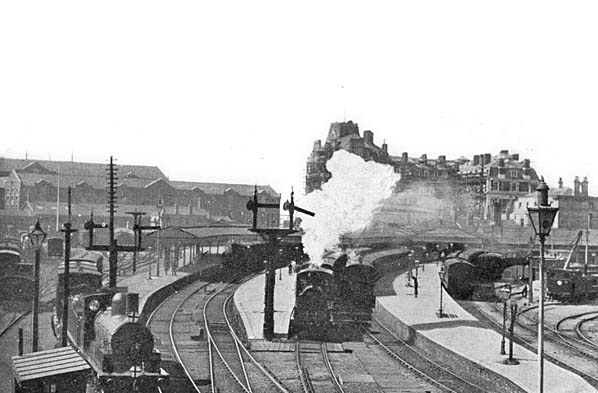
Southampton West Station early 1900s.

Southampton West Station early 1900s.

Southampton Central Station 1935.

Southampton Central Station Bomb Damage WW2.

Southampton Tunnel: Geological problems plagued the construction and delayed its opening. The fundamental issue was that the ground was already compromised by the partial construction of the Salisbury and Southampton Canal tunnel in dating from around 1790, which the railway tunnel crosses at an acute angle and slightly higher.
The railway was completed in June 1847 but because of delays in construction the tunnel did not open until August of that year. For the first four months locomotives and coaches needed for the opening had to be taken across town on lorries pulled by many horses.
Southampton Central Station in 1960s.
Joe Bartlett Photos
Southampton West End/Bletchynden Station
The Southampton & Dorchester Railway was opened to traffic in 1847. It was connected to the original L&SWR main line (from Southampton Terminus) at Northam and travelled westwards by way of a tunnel under the centre of the town. Provision of a station to the west of the tunnel was a condition of building the line but nothing had been done until just before opening as a station here was opposed by the L&SWR. The local council threatened legal action to stop the line opening so in the week prior to the opening ceremony taking place the company hastily put up a temporary terminus at Bletchynden Terrace. Construction problems with the new tunnel had caused its closure for remedial works and the L&SWR had to transport its locomotives by road to Bletchynden and engines and carriages for the makeshift opening day service were horse-drawn through the tunnel as it was considered too dangerous to use steam power.
The first passengers were carried through the tunnel on what was essentially a test train in July 1847 and regular passenger use began in August 1847. This arrangement lasted until 1850 when structures originally destined for Cosham were erected at the site. The improved station was still very simple but from August 1858 it became officially known as Southampton West End. It was subsequently enlarged in1860. The station was often referred to as Southampton West on tickets.
By the late 1880s the station was woefully inadequate for the amount of traffic and the railway purchased land to the west of Bletchynden, where a much larger Southampton West (later Central) station was built and opened in 1895. The old West End station (ex Bletchynden) was then relegated to handling goods traffic, the up platform eventually being cut back to accommodate a siding while the buildings on the down side were removed to make way for additional tracks into the improved Central Station in 1934. What was left slowly fell out of use and almost all traces had disappeared by the 1960s.
Southampton West End Station map 1897.

Southampton West End Station 1890.

Southampton West End Station 1895.

Southampton West End Station 1933.

Southampton Terminus
The station, by Sir William Tite, opened in 1839 as Southampton, although it was not officially operational until 1840, due to the track not being fully linked between Winchester and Basingstoke. In 1839 there was a temporary terminus in Southampton called Northam Road, the temporary station was closed when the line was completed and the permanent Southampton Terminus was opened in 1840 to the design of Sir William Tite. The LSWR added the large South Western Hotel. The line was later extended into the Ocean Dock Terminal to allow boat trains to terminate on the quayside. Due to a dispute the station was excluded from passenger operations and tickets were issued at a small open platform known as Southampton Northam Road just to its north. Initially Southampton was an 'open' station and a 250' platform for collecting and examining tickets was provided north of the Bridge Road crossing (later Central Bridge), and ticket examination was later undertaken at Northam when that station was opened in 1872.
Initially it had two platforms with an engine shed and turntable built in 1847.
During 1858 Southampton was renamed Southampton Docks to distinguish it from Southampton West Railway Station. In 1896 the station was again renamed to Southampton Town & Docks, later changing to Southampton Town for Docks in 1912 and finally being renamed to Southampton Terminus in 1923. During the 1860s, additional sidings and sheds were built, followed by the Imperial Hotel later renamed as the South Western Hotel. The building was acquired by the military in the Second World War and became HMS Shrapnel. After the war it was renamed South Western House and was converted to offices. In 1961 the BBC used it for their local news programme until 1991. The building was converted into private flats in 1998.
More development took place during the early 1870s when land on the station's eastern side was purchased, which allowed the railway to expand. Much larger goods sidings, a telegraph office and buildings for shipping businesses were built. At the same time the platforms were extended.The London and South Western Railway purchased more land during 1876, north of the terminus, and built new locomotive work sheds and a turntable. Three new platforms, two arranged as an island were opened 1891. The goods and parcel yard which were located at St. Lawrence Road were improved. In 1895 the old 1847 engine sheds were still heavily in use but as demand rose for goods, they were converted into a one road depot for freight trains. The original turntable was replaced with an open turntable which was closed and removed in 1966.
Motive power depots were situated at Southampton Terminus Station and nearby in Southampton Docks. The first of these was opened in1839, but was demolished due to track widening. This was replaced by another structure adjacent to the goods shed, but this was closed in 1895. It was replaced by an outdoor servicing facility north of the station, which included a turntable coal stage and offices. These remained open until 1966.
As road transport became more common the platforms at Southampton Terminus began to shrink, first to accommodate a private road between the railway station and the hotel. To make the station more comfortable for its users, a glass canopy was erected in 1924. Two years later in 1926 a new parcel and mail office was built. Around this time the station platform numbers were reversed and numbered to left to right from the prior right to left.
The station closed for passengers and parcels in 1966. By 1970 the remaining signal box and track work was removed and the running lines filled in to platform level to act as a car park. Although the platforms have been demolished the freight line to Eastern Docks still passes the site of the station. Traffic is mainly freight with occasional boat trains direct to Waterloo.
Southampton Terminus Station late 1800s.

Southampton Terminus Station mid 1900s.

Southampton Terminus Station layout 1928.

Southampton Terminus Station Building late 1800s.

Southampton Terminus Station Building 1900.

Southampton Terminus Station Engine Shed.

Southampton Terminus Station, looking south,1904.
Southampton Terminus Station, looking south,1905.

Southampton Terminus Station in 1950s.

Southampton Terminus Station after closure.

Southampton Terminus Station in 1969.

Southampton Terminus crossing Canute Road 2007.

Southampton Terminus crossing Canute Road 2006.

Southampton Royal Pier
The Victoria Pier (as then named) opened in 1833 and with the opening of Southampton railway Station in 1840 passengers were conveyed to the pier steamers by horse drawn omnibus. A tramway from Southampton station (renamed Southampton Docks in 1858) to the Town Quay had been laid down by 1847. The tramway connected to the the LSWR main line via a wagon-turntable, so passenger carriages could not access it. In 1864 a floating pontoon and bridge were incorporated at the angle of pier neck and head. The tracks were extended to a new station on the pier in 1871 with a new direct connection at Southampton Docks station allowing trains to run through and on to the pier. The LSWR had leased the horse drawn tramway since 1851 and sought to run a steam service from the Docks station, the service began in 1876 although the station didn't appear in public timetables until 1891. Initially, the pier station consisted of just a single open wooden platform with a run round loop for the loco, but when the pier was substantially rebuilt and enlarged in 1892, a new station was constructed with two platforms, each complete with canopies; a pier head pavilion was added in 1894.
The station and track had badly deteriorated by the outbreak of WWI and passenger services officially ceased in 1914 but some troop movements were carried out during the hostilities. Later a ship collided with the pier and damaged the already semi derelict infrastructure and track. The cost of restoration was considered too costly and most of the railway, including the station, was removed in the early 1920s. The pier pavilion was extended in 1922 and a new domed pier entrance building was added in 1930.
By 1979, the pier was becoming unsafe and was not economic to maintain and it closed in 1982. Plans to rejuvenate the pier were formulated and the Victorian entrance was restored, and re-opened as a pub/restaurant in 1986. Further regeneration was cut short in 1987 when a serious fire completely destroyed the pavilion and bandstand at the pier head. A subsequent fire in 1992 destroyed much of the pier neck and caused serious damage to the conservatory at the rear of the gatehouse.
Southampton Royal Pier map late 1800s.

Entrance to Royal Pier map mid 1900s .

Southampton Royal Pier Layout.

Southampton Royal Pier Station 1880.

Southampton Royal Pier Station 1892.

Southampton Royal Pier Station 1900.

Southampton Royal Pier pre 1903.

Southampton Royal Pier pre 1910.

Southampton Royal Pier Pavilion 1912.

Southampton Royal Pier Entrance 1930's after removal of Railway.


Southampton Royal Pier 2006.

Southampton Docks and Town Quay
The 16th and 17th centuries were a period of decline for Southampton, as other ports (such as London) competed for business; the port was generally quiet until the second half of the 18th century. There was a period during which Southampton was better known as a fashionable spa town and sea-bathing resort than as a port. Trade gradually increased, and soon the port was handling wine and fruit from Spain and Portugal; grain from Ireland and eastern England; woollen stockings from the Channel Islands; slate and building stone from Scotland; coal from Newcastle and Scotland, and timber from the Baltics. Paddle steamers began passenger service to the Channel Islands and Le Havre in 1823. They berthed at Watergate Quay (now the site of the Town Pier), but could only do so at high tide. The original wooden Royal Victoria Pier was opened in 1833, and provided berthing facilities at all tidal depths.
The opening of the railway to London in 1840 gave a boost to the port. Ships began arriving in numbers that overwhelmed the town's quays and wharves, and the first dock was inaugurated in 1843. This became known as the "outer dock" when a second, "inner" dock began use in 1851. Berths along the Itchen Quays, South Quay and Test Quays became available for use between 1875 and 1902. In 1890 Queen Victoria opened the Empress Dock, larger and deeper than earlier ones. Four dry docks for ship maintenance were constructed, opening in 1846, 1847, 1854 and 1879. The Southampton Harbour Board Police was founded in 1847, and policed the port and its environs.
P&O was the first deep-sea shipping line to use the port, beginning service in 1840. Others moved in: the Royal Mail Steam Packet Company arrived in 1842, with service to South America; the Union Line began service to South Africa in 1857. Of the trans-Atlantic companies, the American Line was first in 1893; White Star moved in from Liverpool in 1907, followed by Cunard in 1919. Another large dock was constructed, opening in 1911 completing the Eastern Docks system. First known as the White Star Dock, its name was changed to Ocean Dock in 1922 when Cunard and Canadian Pacific also used it. In 1892 the Royal Pier reopened (now built of iron instead of wood). That year, the London and South Western Railway (which had greater financial resources than the locally owned docks company) became owner and operator of the docks.
Many new ships were too big for the four dry docks, so a fifth (the largest in the world) was constructed in 1895. When ships outgrew that, a sixth (larger) dock was opened. The sixth dock was extended twice. When ships grew larger still, a floating dry dock arrived in 1924, and was based at Berth 50. The dock was moved to Portsmouth during the Second World War, and in 1959 it was sold to Rotterdam. In 1983 it was sold to Brazil, but it sank on the way there.
The "New Docks" opened in 1934; this was actually a single quay. At the western end of this was the seventh dry dock, the King George V Graving Dock, which opened in 1933. The New Docks are currently known as the Western Docks. At the Ocean Dock, the Art Deco Ocean Terminal opened in 1950 to provide shore facilities for the Queens and other Atlantic liners. Downstairs were trains to London. The Ocean Terminal was demolished in 1983. The Queen Elizabeth II passenger terminal was opened in 1966 to augment (and replace) it, which remains in regular use. That terminal in turn is augmented by the 2009 Ocean Terminal, across the dock from the old.
From the earliest days the docks, just across the road from the Terminus Station, had rail connections to its quays. The Southampton Dock Company had close liaisons with the London & South Western Railway which, after some years of financially supporting them, eventually purchased the docks in 1892. After that date, rail facilities within the docks and connections to the main line developed rapidly. Many of the terminals were stations in their own right.
Motive power depots were situated at Southampton Terminus Station and nearby in Southampton Docks. The first of these was opened in1839, but was demolished due to track widening. This was replaced by another structure adjacent to the goods shed, but this was closed in 1895. It was replaced by an outdoor servicing facility north of the station, which included a turntable coal stage and offices. These remained open until 1966.
An engine shed was opened in Southampton Docks, by the Southampton Docks Railway Company in 1865. It was rebuilt in 1879, and taken over by the London and South Western Railway in 1892. The building was enlarged and re-roofed by the Southern Railway during the 1930s and rebuilt by British Railways in 1955. It was officially closed in 1966, but remained in use until 1967. The Southern Railway opened an outdoor locomotive servicing facility in the New Docks in 1933 and added a turntable in 1949. This remained in use until 1966.
Southampton Docks Layout.
Southampton Town Quay map late 1800s.
Southampton Docks map late 1800s.

Southampton Docks map mid 1900s Part 1.

Southampton Docks map mid 1900s Part 2.

Building Southampton Docks.

Southampton Empress Dock early 1900s.

Southampton Floating Dock early 1900s.

Southampton Floating Dock with Liner.

Southampton Workman's Station early 1900s.

Southampton New (Western) Docks 1930s.

Southampton Docks 1950s.

Southampton Docks mid 1900s.


Southampton Town Quay 1970s.

For almost 40 years a flying boat services were operated from Southampton. During that period five different locations were used as terminals. The very first was the Royal Pier which was used by Supermarine during the summer of 1919; They operated services that only lasted a few weeks to Bournemouth,Portsmouth and the Isle of Wight. In September 1919 Supermarine operated the first international flying boat services from their base at Woolston to Le Havre. The service ceased after a short time,and it was not until September 1923 that any further international services were operated.In September 1923 The British Marine Air Navigation Company jointly owned by Supermarine and Southern Railway, started operating a service from Woolston to Cherbourg. In 1924 British Marine became Imperial Airways and as such, continued to operate flying boat services from Woolston until 1929.The next development was the commencement of the 'Empire' services in March 1937 when Imperial Airways started services to Alexandria and later that year to South and East Africa. On 5th July 1937 the first Transatlantic service was started with flights from the UK by Imperial and from the USA by Pan American. The Imperial Airways terminal was at 101 Berth in the 'Western Docks.
After WW2 BOAC recommenced operations, initially at Poole, but on 14th April 1948, services moved back to Southampton. British Railways, the then owners of Southampton Docks, had completed the building of a specially designed marine air terminal at 50 berth in the Eastern Docks. The flying boats could dock alongside. Despite these new surroundings, aircraft development was moving rapidly toward jet transport and higher speeds and flying boats were becoming uneconomical. BOAC announced the phasing out of flying boats by 1949 and they ended their operations on 3rd November 1950. BOAC's flying boats were sold to Aquila Airways became the sole operator of flying boats in Britain for nearly 10 years operating from the terminal at Berth 50 but ceased trading in September 1958 when the last trains ran into the terminal at Berth 50.
Southampton Flying Boat Locations from 1919 to 1958.
"A" = Supermarine Woolston...."B"= 101 Berth,New(Western) Docks...."C"= 108 Berth ,New(Western) Docks...."D" = Town Quay...."E" = Royal Pier....."F" = 50 Berth.

'Ile de France' boat train at the Southampton Flying Boat Terminal 1949.

Southampton Flying Boat Terminal 1949.

Southampton Flying Boats.


Flying Boat Berth 50 in the Old Docks today.

Southampton Docks Videos.
1958
BOAC Marine Flying Boat Terminal 1948
Floating Bridge
The Woolston Floating Bridge:
The Woolston Floating Bridge was a cable ferry that crossed the River Itchen between Woolston and Southampton from1836 until 1977. Initially there was one ferry, built and owned by the Floating Bridge Company, increased to two in 1881. In 1934 they were sold to Southampton Corporation. Today one of the ferries is used as a restaurant.
Click here for Floating Bridge history.
Floating Bridge map early 1900s.

Floating Bridge.

Northam (and Northam Road) Station
The London and Southampton Railway (L&SR) was opened in stages. Most of the portion south of Winchester was opened in 1839, to a temporary terminus in Southampton called Northam Road. The temporary station was closed when the line was completed and the permanent Southampton Terminus was opened in 1840. The need to open a temporary station at Northam Road arose because of a dispute during construction of the line. There was an disagreement between the L&SR and the Northam Bridge Company (NBC), owners of the Northam Bridge, concerning how the railway would cross Northam Road, which connected the bridge with the centre of Southampton.
During the 1860s, Northam residents campaigned for a local intermediate station, but the LSWR was not in favour because Northam would be only a short distance away from the main terminus, which would become known as Southampton Terminus. Nevertheless, a site was investigated between, what is now, Mount Pleasant level crossing and the current South West Trains train depot. Eventually the station was built on the south side of Northam Road bridge, not far from where the temporary terminus once stood. The new Northam station opened in 1872.
Northam station closed in 1966 and demolished in 1969.
Northam Station map late 1800s.

Northam Station map mid 1900s.

Northam Station 1907.

Northam Station early 1900s.

Northam Station 1950.

Northam Station 1964.

Northam and Belvedere Industrial Estates
During Victorian times, much of Southampton's industry was based around the banks of the Itchen, and Northam was home to the Summers and Day iron works which launched the first iron ship to be built on the Itchen in 1842.
The London and South Western Railway opened a large Motive Power Depot at Northam in 1840, which remained the principal locomotive servicing facility in the area until 1903 when it was replaced by a new depot at Eastleigh.
Northam map late 1800s.

Northam map mid 1900s.

Northam and Belvidere map mid 1900s.

Industrial Estates mid 1900s.


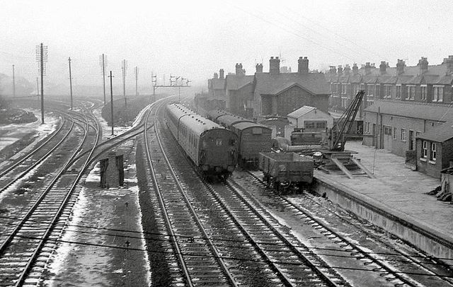
Bevois Park Sidings
Bevois Park Sidings map early 1900s.

Bevois Park Sidings late 1900s.

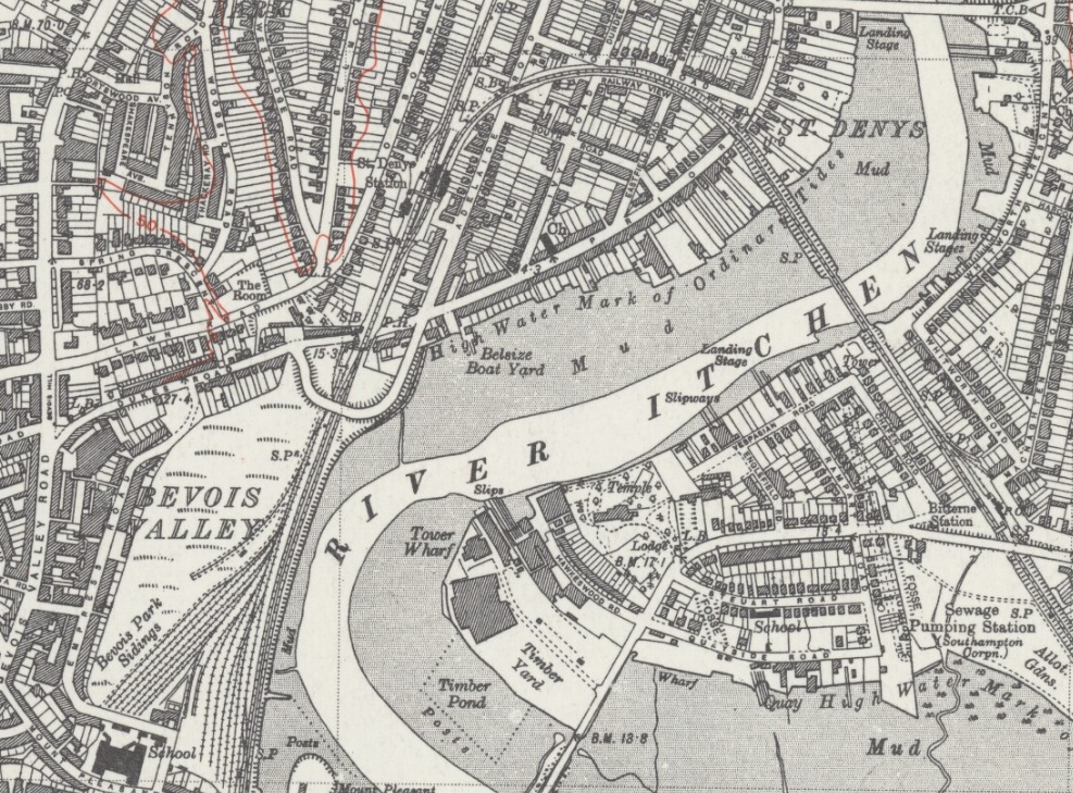
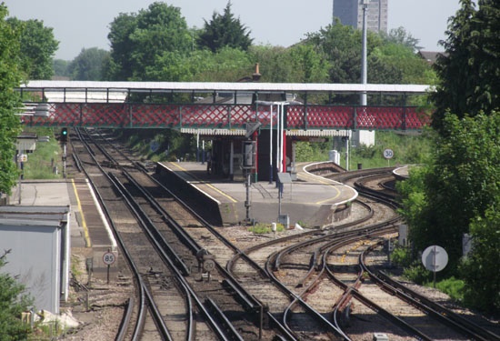
St Denys Station
Built in 1865, the station is named after the surrounding area, which in turn is named after the Priory of St Denys, a major landmark in medieval Southampton. The original station was opened by the London and South Western Railway in 1861 and named Portswood. Shortly after, to accommodate the Portsmouth branch line, a new station building was built 1/4 mile to the south (?); the relocated station was opened in 1866. However to avoid confusion with Portsmouth, the station was renamed to St Denys in 1876.
Portswood Station map late 1800s.

St Denys Station map mid 1900s.
St Denys Station.

St Denys Station mid 1900s.

Portswood/Southampton Common Racecourse:
Horse racing on the Common started in 1804 (although officially some time later), when Southampton was enjoying a revival as a spa town. It was an annual event spread over two days, and planned to attract more visitors to the town. The programme included bare knuckle prize fighting staged in front of the racing stand.
Horse racing had been a popular sport in Southampton from 1791, when the nobility and gentry 'carriage folk' indulged their love of horses and betting with organised meetings at Shirley, Stoneham, and Netley Common. However, by the early 1800s Southampton was losing its kudos, not least because the Prince Regent favoured Brighton, and so for a while horse racing had lapsed in the town. The new course on the Common was one and three quarters miles around and included within its circuit both the boating lake and artesian well. It looped through the southern part of the Common, but this section was shortened after the mid 1840s, when it was turned into Hill Lane cemetery. The race stand, lined with green baize, was placed near the north turn on the west side of the course facing east.
During the late 1830s the coming of the railway, and development of the docks, changed the atmosphere in Southampton from genteel to industrial. And after 1837 it became increasingly difficult to raise enough subscriptions to employ a steward of sufficient social standing to attract gentlemen of quality. Racecourse debts and expenses grew, and in 1848 the committee had little choice but to sell off the posts, stands, and rails. Although, as it turned out, this lapse was only temporary.
Horse racing on the Common was revived again in 1859 when there were two or three golden years. The races were attended by a wide spectrum of society. The gentry arrived in their fine carriages. Well to do farmers sporting white top hats came with farm wagons filled with excited country folk dressed in their Sunday best. Southampton's working classes were conveyed from the Six Dials in St Mary's for 3 pence per head. However, by the mid 1860s newspaper reports were beginning to express disappointment with both the attendance and the quality of the entries. Decline set in again, and by 1874 there was a conspicuous absence of gentleman's carriages. There was increase in disorder, rowdyism, drunkenness, and crime. Eventually the course closed with the last race in 1882.
Click here for full history.
Southampton Common Racecourse map late 1800s.

Shirley Racecourse map late 1800s.

Southampton Airport Parkway (Atlantic Park Hostel) Station
Opened on the site as the Atlantic Park Hostel Halt in 1929 though later closed. In 1966 a station was built as Southampton Airport before changing to Southampton Parkway (in 1986), with another name change in the 1990s to Southampton Airport Parkway.
After WW1 the site became a transit camp for refugees, mainly Russian, who were anxious to sail to America from the port of Southampton. The shipping companies Cunard and White Star Line (the Oceanic Steam Navigation Company) together with the Canadian Pacific Railway formed the "Atlantic Park Hostel Company" to house them temporarily. In 1921 the hangars were converted into dormitories, kitchens and dining rooms.
The hostel was intended to be a short-term clearing house for those trans-migrants changing ships, but following changes to US immigration law which restricted entry to the United States under national origins quotas, some residents were forced to stay much longer. In 1924 about 980 Ukrainian Jewish would-be emigrants were cared for at the hostel. Some of them were still there seven years later, stranded between the US and UK which would not accept them, and unable to return the countries they had fled. Atlantic Park had a school, library, and synagogue while the refugees formed football teams that played local sides and took part in local events, such as Eastleigh carnival. At the height of its use 20,000 passed through Atlantic Park in 1928 but then figures started to fall away, leading to the closure of the hostel in 1931.
Southampton Airport:
The site at North Stoneham Farm was first used for aviation in 1910 when Rowland Moon took to the air in his tractor monoplane "Moonbeam II". During 1910 and 1911 the field was also used by Graham White and Maurice Tetard, but nothing further occurred until the War Office decided to build an Aircraft Acceptance Park on the site in 1917. Before completion the site was handed over to the US Naval Air Service as NAS Eastleigh in 1918.The USN used Eastleigh for the assembly and flight testing of aircraft destined for the war front in France until 1919 when the site passed back to RAF control. The RAF pulled out in 1920 and the station closed officially in May of that year .However for the next 12 years civil aircraft continued to use the airfield as an unlicensed landing ground.
In 1929 the Southampton Council purchased the land and, in 1932 officially reopened the airport. Airline services started in 1934,and in 1935 the Fleet Air Arm started using a site in the NE corner of the airfield as "RAF Eastleigh", but the name was changed to RAF Southampton in 1936 (this was later to become HMS Raven on 1939). In 1936 Supermarine moved in, setting up a flight test facility from where the Spitfire made its first flight.
After the War Eastleigh returned to civil control April 1946, the airfield being operated by the Ministry of Civil Aviation. Airline services, resumed in 1945,continued to prosper. During the 1950s a mainstay of business for the airport was the Cross channel car ferry service operated by Silver City Airways.
Click here for full history.
Atlantic Park Hostel Halt map mid 1900s.

Southampton Airport Station late 1900s.

Swaythling Station
Built in 1883 in an elaborate Neo-Flemish style. The station building was set back to the east of the down platform so that it would not have to be rebuilt in the event of the double track being widened to quadruple tracking, but has never taken place.
Swaythling Station map late1800s.

Swaythling Station 1905.

Eastleigh (Bishopstoke) Station
The station was called Bishopstoke when it was opened in 1839. The station-house was designed by Sir William Tite. It was renamed Bishopstoke Junction in 1852 (the branch to Fareham and Gosport having opened in 1841), Eastleigh and Bishopstoke in 1889, and finally Eastleigh Station in 1923. The station has been a busy and important junction throughout its life, having gained a second branch line to Salisbury via Romsey in 1847 and a large carriage & wagon repair shops (later to become Eastleigh Works) in 1891.
Bishopstoke Junction Station map late1800s.

Eastleigh Station map early 1900s.

Eastleigh Station and Carriage Works map mid 1900s.

Eastleigh Station 1900.

Eastleigh Station 1910.

Eastleigh Station 1963.
Eastleigh Station 1964.

Eastleigh Station 1984.

Eastleigh Station in 1960s.
Ian Nolan Photos
Mike Morant Photos
Joe Bartlett Photos
RailScot Photos
Eastleigh Carriage Works and Sheds
The London and South Western Railway (LSWR) opened a carriage and wagon works at Eastleigh in 1891 and a large motive power depot in 1903. In1910 locomotive building was transferred to the new workshops at Eastleigh from Nine Elms in London. Steam locomotive building ceased in 1950, however the works were kept fully occupied between 1956 and 1961 in rebuilding over 90 of the Bulleid 4-6-2 classes. Thereafter the works gradually changed over to steam and diesel repairs. In 1962, the works was again reorganised with the carriage works site being sold, and carriage and electric multiple unit repairs transferred to the main locomotive works.
Adjacent to the locomotive works was a very large 15-road engine shed which was opened in 1903 and closed in 1967.
Eastleigh Works 1910.

Eastleigh Engine Shed 1946.

Eastleigh Works 1950s.
Eastleigh Works 1960s.

Eastleigh Works and Shed.
Joe Bartlett Photos
RailScot Photos
Twyford Waterworks
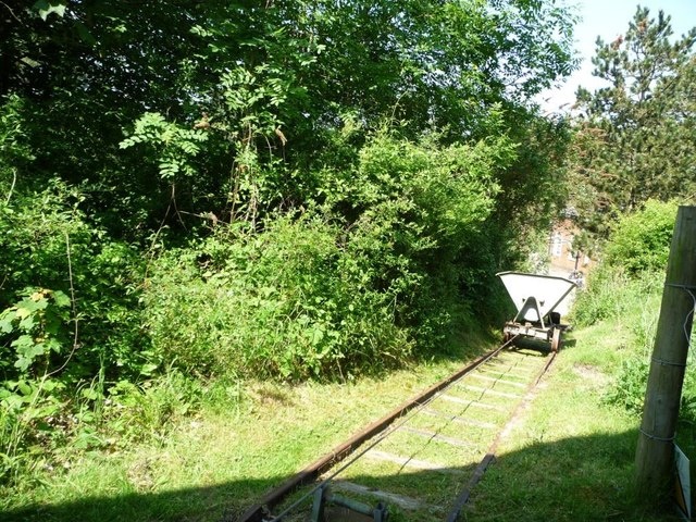
Opened in around 1900. A 2ft 0in gauge railway to transport materials around the site was laid soon after the site opened. Initially the railway connected the coal storage area to the Boiler House to move coal in and ashes out. After 1903 the railway was extended into the quarry and up to the lime kilns to move chalk and coke to the lime kilns. Further tracks allowed the lime to be moved to a storage room. Standard skip wagons were used for all operations and these were pushed by hand on the level sections and pulled by rope up the inclines. Much of this railway remains in place today.
Twyford Waterworks map early 1900s.

Twyford Waterworks Trains.

Shawford Junction
Shawford Junction opened in 1891 where the Didcot, Newbury and Southampton Railway (DN&SR) joined the London and South Western Railway (LSWR).
Shawford Junction map early 1900s.

Shawford Junction mid 1900s.

Shawford Station
Built in 1882
Shawford Station map early 1900s.

Shawford Station mid 1900s.

Winchester Station
Winchester Station was opened in 1839. It became a temporary terminus for the Winchester to Southampton section. On the same day, another station was opened at Basingstoke, which was a temporary terminus of the London to Basingstoke section.The following year, a line was built joining Winchester and Basingstoke and the line was complete.
Later, the Great Western Railway built the Didcot, Newbury and Southampton Railway. This passed at a separate station on the eastern side of Winchester called Winchester (Chesil). In 1949, it was renamed Winchester Chesil, whilst Winchester's main station was renamed Winchester City. In 1966 Chesil closed and the following year, City station was changed back to simply Winchester.
A small engine shed was built by the Southern Railway in 1927. This housed a shunting locomotive which worked in the local goods yard. It was closed together with the goods yard in 1963.
Winchester Station map late 1800s.

Winchester Station map late 1900s.

Winchester Station in 1950s.

Winchester Station now.

The extensive course of 2 miles in length with a 6 furlong straight, much of it uphill, was located four miles north of the city, near the village of South Wonston close to Worthy Down army camp. The earliest record of racing in Winchester was in 1664, although no further details were provided. Records then lapse until a two-day meeting was held in 1676. In 1683 Winchester races became Royal Winchester when King Charles II attended, and by the latter part of the 17th Century races were held annually towards the end of August. Races continued to be popular and well supported for a further 130 years. Although the final meeting took place on Wednesday 13th July 1887, the grandstand still existed until 1917 when the wood was used to build some racecourse cottages in the village.
Further information can be found at Greyhound Derby.
Winchester Racecourse map late 1800s.

Worthy Down was built on the old Winchester Racecourse, which was acquired for the purpose in 1917.The airfield opened in 1918 for use by the RAF, who retained control until 1939 when control passed to the Admiralty, and the station became HMS Kestrel. During WW2, in addition to the FAA use, Supermarine used the airfield for Spitfire development flying. Post war flying was reduced and in 1950 the station closed after 2 years on Care and Maintenance. In 1952 the airfield was reopened as HMS Aerial II with the Air Electrical School in occupation. No flying units were based there. In 1960 the airfield was closed.
Further information can be found at Hampshire Airfields.
Worthy Down Airfield map 1950s.

Worthy Down Airfield 1930s and 1946.


Winchester Chesil Station
Winchester (Chesil) station was opened with the line from Newbury in 1885, originally being named Winchester Cheesehill. Originally a terminus, since the intended line southwards to Southampton was never completed, it became a through station in 1891 when a connecting line to the London and South Western Railway (LSWR) was opened, joining the latter at Shawford Junction.The station closed temporarily in 1942, reopening in 1943. The station was renamed from Winchester Cheesehill to Winchester Chesil in 1949.
Further to the south of the station was an area of extensive sidings known as the Bar End Yard. There were 4 sidings, two passing loops, a large goods shed, and a ten-ton crane. The goods facilities were withdrawn in 1966. To the east of the line, adjacent to the goods shed, there was an engine shed which opened in 1885 and closed in July 1953.
Like the other stations on the southern part of the line, Winchester Chesil closed on 7 March 1960; but unlike the others, it was reopened for the next two summers: 18 June 1960 to 10 September 1960 and 17 June 1961 to 9 September 1961, on Saturdays only.
Winchester Chesil Station map late 1800s.

Winchester Chesil Station early 1900s.

Winchester Junction
Junction of the London and South Western Railway (LSWR), the Didcot, Newbury and Southampton Railway (DN&SR), and the London and South Western Railway (LSWR) Alton and Winchester line.
Winchester Junction map early 1900s.

Micheldever Station
Built in 1840 by Sir William Tite. Known as Andover Road until 1856 when Andover got its own station. For a short time the railway line terminated at Warren Farm.
The railway should never have passed through the Dever Valley. The shortest and most economical route from London to Southampton was via Guildford and Alton. But following much lobbying by the merchants of North Hampshire against that plan, a longer route was chosen – passing through Dummer and East Stratton. However, the line was eventually built through the Dever Valley on the instruction of the Chairman of the London & Southampton Railway Company, Sir Thomas Baring, M.P. who lived at Stratton Park and had no wish for the line to be within sight nor sound of his residence! Francis Giles, the appointed engineer for the project, commented at the time... "The line was therefore carried through a barren and desolate country, where the soil was so valueless, that the landowners were glad to get rid of it at any price."
A major development of Micheldever Station took place during the Second World War. In 1943, the Southern Railway was asked to assist the war effort. A total of seventeen sidings were built and became home to an Ordnance Emergency Depot, staffed by hundreds of soldiers. Micheldever Station soon became known as 'the Woolworths depot' thanks to its ability to provide virtually anything that could possibly be required by the military. A shed, over 2,000 ft long was built to house the depot. Orders for stores received by late afternoon were packaged and left the depot by train that night and often reached Normandy the next day. Another essential supply service was also focused at Micheldever during the war - petroleum, oil and other lubricants. Over 18,000 gallons were stored in the tanks dug into the side of the railway cutting at Micheldever Station. It is rumoured that oil was then pumped through a pipeline that ran alongside the railway track to the coast and across to the Isle of Wight. From there it was pumped under the English Channel to the site of the D-Day landings - known as PLUTO ('Pipeline Under the Ocean')
Micheldever Station map late 1800s.

Micheldever Station map early 1900s.

Micheldever Station early 1900s.


Micheldever Station signal box early 1900s.

Micheldever Station late 1900s.

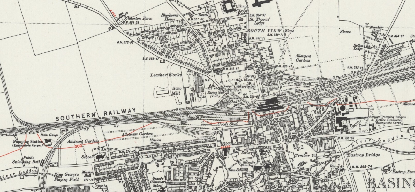
Basingstoke Station
Opened by the London and South Western Railway as a temporary terminus when its line to Southampton reached Basingstoke from London. It became a through station in 1839 when a small station was built which was replaced by one designed by Sir William Tite about 1850 .
A second railway reached Basingstoke in 1848 when the broad gauge Great Western branch opened from Reading with a station with an overall roof being built north of the LSWR station. It was not possible for trains to pass from one railway to the other due to the difference in gauge and a Transfer shed was built where goods could be transferred across a platform from a broad gauge wagon to a standard gauge one. This system only lasted until 1856 when the GWR laid a standard gauge rail on its broad gauge track. The broad gauge rail was removed in 1869. Tite’s station was enlarged, the two LSWR tracks were increased to four and the Chapel Street Bridge enlarged in 1875 and again in 1903. At this time the third LSWR station was built in a Neo-Tudor style in rich red brick to the south, town side, of the running lines and at a lower level with a subway giving access to the platforms. In 1932 trains from Reading ran into the main station and the GWR building was demolished. Both railways had large goods sheds and extensive goods sidings but these have mostly been demolished and the ground used for large car parks.
Basingstoke station was the terminus of the Basingstoke and Alton Light Railway, opened in 1901 to prevent the GWR from building a line on this route towards Portsmouth. The line was never profitable. During the First World War some of the track was sold off. After the war, Southern Railway had the line reopened, but it was closed finally in 1932.
The standard gauge London and Southampton Railway, soon to be London and South Western Railway, opened to Basingstoke on 10th June 1839[1] when a small station was built. This was replaced by one designed by Sir William Tite about 1850 similar to that still in existence at Micheldever. A second railway reached Basingstoke in 1848[2] when the broad gauge Great Western branch opened from Reading with a station with an overall roof being built north of the LSWR station.
Basingstoke Station map late 1800s.
Basingstoke Station map mid 1900s.
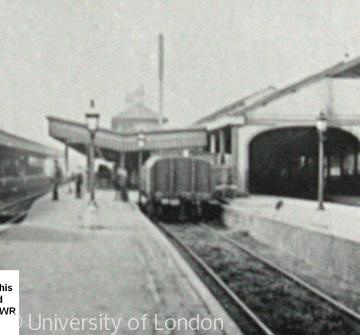
Basingstoke Station mid 1900s.

Basingstoke GWR Station mid 1900s.
Basingstoke two stations early 1900s.
Basingstoke Canal
The first route to be surveyed in 1769 was a line northwards to the Thames at Monkey Island, Bray, but the engineering problems proved it would be too costly. In 1776 a 44-mile route eastwards from Basingstoke, to link with the River Wey Navigation and the Thames at Weybridge, was considered. The route included a loop round Greywell Hill that took the canal up to Rotherwick, with a short arm going to Turgis Green, but this met with opposition from the owner of nearby Tylney Hall. As a result, a decision was made to tunnel through Greywell Hill rather than go round it, however work did not commence until nine years later. The canal was completed in 1794 built to connect Basingstoke with the River Thames at Weybridge via the Wey Navigation. There were plans to extend the canal to Portsmouth, Southampton and westward to Bristol via the Kennet & Avon Canal opened in 1810. None of the schemes for links to other waterways materialised. By 1866 the original canal company was bankrupt. Commercial use ended in 1910 but low-level use of the canal continued. During World War I the Royal Engineers took over the running of the canal and used it to transport supplies from Woolwich. By the late-'60s it was essentially derelict despite volunteer efforts to improve the situation. After about 18 years of restoration, 32 miles (51 km) of the canal were formally re-opened in 1991. The western section from North Warnborough to Basingstoke remains un-navigable from the point at which it enters the Greywell Tunnel. The tunnel partially collapsed in 1932 where it passes from chalk into clay geology, and is now inhabited by a protected bat colony making it unlikely that the tunnel will ever be restored. Some of the former canal basin at the western end has also been lost to modern development in and around Basingstoke.
Basingstoke Canal route.

Pictures of the Canal.


Canal railway.

The original introduction of narrow gauge was in the form of twenty yards of track at Colt Hill where dredging was being carried out in 1975. Skips full of silt dredged from the canal were push and dragged along the track to be dumped on a neighbouring area. As the dredging moved further from the dump site the track grew steadily to 800 feet long and man handling became impractical leading to the purchase of a Hudson Hunslet 22hp diesel locomotive. This modest introduction to narrow gauge on the canal was to lead to greater things when the equipment was moved to Deepcut where it extended to 1.5 miles length. Although it's stay there only lasted a couple of years the little line hauled 7,000 tonnes of building materials to the locks before being moved again to Ash embankment.
Park Prewett Hospital
Operated from 1917 until 1997. The hospital was served by its own railway line from 1913 until 1950 (track lifted in 1956) from a junction on the South Western Main Line. The line was mainly for a coal train as the curves were too tight for passenger wagons.
Basingstoke Station and Park Prewett Railway.

Hook Station
Built in 1883 after a lengthy campaign by local landowners. Expanded to four platforms and tracks in 1901-2, the middle island platform was removed around the 1960s.
Hook Station map late 1800s.

Hook Station map mid 1900s.

Hook Station.

Winchfield Station
Winchfield station was opened in 1838 as Shapley Heath (and maybe also called Winchfield and Shapley Row) being a temporary terminus on the London to Basingstoke line. By 1840 it was renamed as Winchfield.
Winchfield Station map mid 1900s.

Winchfield Station 1860.

Winchfield Station 1861.

Winchfield Station early 1900s.

Fleet Station
The railway line through Fleet was built in 1839; Fleet at that time did not have a railway station. A station, originally named Fleet Pond 1847 and renamed Fleet in 1869. However, the amount of traffic at the station was so little that in 1858 there was a proposal to abolish the station completely although this never happened. In 1854 the War Department had purchased Fleet Pond and much of the surrounding area as a training ground for the Crimea War (1854-56). In 1897 the LSWR purchased a further area of land from the War Department to allow the widening of the line, construct the new station and a goods yard. The move to the new station was completed in 1904. During the electrification process in the 1960s Fleet station was redeveloped with the Edwardian station building and goods office being replaced.
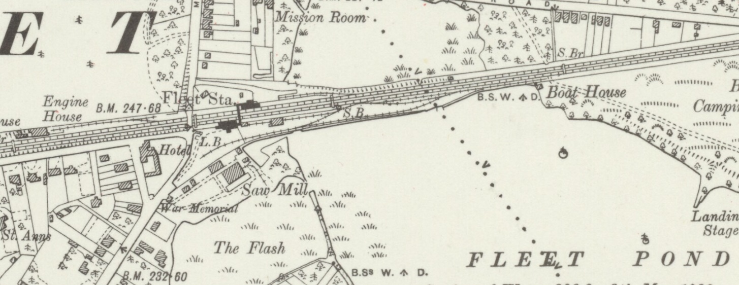
Fleet Station map late 1800s.

Fleet Station map mid 1900s.
Fleet Station 1895 and 1910.


Fleet 1900.

Troops on Fleet railway station platform on their way to the Boer War in 1899.

Fleet Station Milk Floats built by Fleet 1930.

Fleet Pond:
Many bishopric ponds were created in the second half of the 12th Century and Fleet Pond could have been in existence by 1200. The first detailed reference to Fleet Pond was made in 1324 when “the great fishery (of) Fleet Ponds” is referred to in the Rolls of Account of Crondall Manor. At this time, there were two ponds providing a thriving fishery of considerable importance. See History of Fleet Pond.
In 1885 the Royal Engineers built a trestle bridge across the pond.
Today the pond is a Nature Reserve.
Fleet Pond Trestle Bridge 1885.

Fleet Pond Nature Reserve map.

Farnborough Station
Opened in 1838 by the London and South Western Railway (then the London and Southampton Railway), on the line from London to Winchfield (then Shapley Heath). The next year, the line was extended to Basingstoke, then the next year it was connected to Southampton. There is a wide gap between the tracks and originally an island platform stood between them.
In 1849, South Eastern Railway built the North Downs Line, and opened a station also known as Farnborough, but it was not renamed as its existing name Farnborough North until 1923. The main line railway station was often known as Farnborough (Main) and this has become its official name. It was sometimes advertised as 'Farnborough for Aldershot' at an early stage.
Farnborough Station map early 1900s.

Farnborough Station, Shed and start of RAE Branch map mid 1900s.

Farnborough Station 1960s showing island platform.


Frimley and Farnborough Curves
Map early 1900s.

Royal Aircraft Establishment (RAE)
In 1904–1906 the Army Balloon Factory, which was part of the Army School of Ballooning relocated from Aldershot to the edge of Farnborough Common. In 1909 Army work on aeroplanes ceased and the Factory was brought under civilian control and in 1912 the Balloon Factory was renamed the Royal Aircraft Factory (RAF). In 1918 the Royal Aircraft Factory was once more renamed, becoming the Royal Aircraft Establishment (RAE) to avoid confusion with the Royal Air Force, which was formed on 1 April 1918, and because it had relinquished its manufacturing role to concentrate on research. In 1988 the RAE was renamed the Royal Aerospace Establishment.
The RAE railway line, which linked the main Farnborough station with the RAE site ran up Elm Grove Road, across Victoria Road and on into the RAE. The line finally shut down in 1968.
Farnborough Station and RAE Branch map mid 1900s.

RAE Branch images.


Video of Farnborough Station to Royal Aircraft Establishment (RAE).
Youtube Videos
Pirbright Junction
Opened in 1870 as the junction to the L&SWR Aldershot Branch.
Pirbright Junction map early 1900s.

Bisley, Pirbright and Deepcut, Blackdown Camps
A branch line (L&SWR Bisley Tramway) to Bisley Camp was opened in 1890 and closed in 1952.The NRA originally had a temporary shooting range and railway on Wimbledon Common prior to 1888.
The construction of the 3 mile branch line (Bisley, Deepcut and Blackdown Railway) from Bisley Camp was undertaken by Canadian troops as well as Prisoners of War who were being held at Frith Hill to the north of Deepcut. Opened by King George V and Queen Mary, the railway line only had a short life, being discontinued in 1921.The terminus at Deepcut was a log-timbered building, constructed by Canadian troops. The military extension between Bisley Camp and Blackdown Camp was finally dismantled in 1928 although the section between Bisley and Brookwood was not dismantled until 1952.
Initially using a Merryweather steam tram locomotive, the range later used diesel locomotives.
Bisley Camp map early 1900s.

NRA Wimbledon (prior to Bisley) late 1800s

Bisley Station

Bisley Tramway bridge over Basingstoke Canal

Bisley Camp Range Loco

Pirbright Camp map early 1900s.

Deepcut Camp map early 1900s.

Deepcut Station.

Brookwood Station
Opened in 1864 for visitors wishing to visit the cemetary. Reconstructed in 1903,
Brookwood Station map early 1900s.

Brookwood Station.

Brookwood Cemetery
Brookwood Cemetery, also known as the London Necropolis, was opened 1854 and was at one time the largest cemetery in the world. Today, it is the largest cemetery in the United Kingdom and one of the largest in Europe. The cemetery is listed a Grade I site in the Register of Historic Parks and Gardens.
During the 1840's, churchyards in the capital were becoming full, resulting in the Burials Act of 1850 which prevented further burials in London and allowed cemeteries to be built away from the city. It was suggested that sparsely populated areas with good transport links to the capital should be used for these cemeteries. In 1854, 400 acres of the land bought by the 'London Necropolis' company, at Brookwood in the west of Woking Borough, were used for a national cemetery.
Brookwood originally was accessible by rail from a special station – the London Necropolis railway station – next to Waterloo station in Central London. Trains, with passenger carriages reserved for different classes and others for coffins (also for different classes), ready for safe carriage by horse-drawn vehicles ran into the cemetery on a dedicated branch from the adjoining South Western Main Line – a junction was just to the west of Brookwood station. The original London Necropolis station was relocated in 1902 but its successor was demolished after suffering bomb damage during World War II.
Two stations were in the cemetery itself: North for non-conformists and South for Anglicans. Their platforms still exist along the path called Railway Avenue. A commemorative very short piece of track with signpost and plaque which purposefully gives way to a grass field recollects the old final main stage of the journey of the deceased.
Brookwood Cemetery map late 1800s.

Brookwood funeral train 1902.

Brookwood North section (Dissenters') Station early 1900s.

Brookwood South section Station currently.

Video of Brookwood/Waterloo.
Youtube Videos
References:
Wikipedia - Woking Railway Station
Wikipedia - Brookwood Railway Station
Wikipedia - Brookwood Cemetery
Wikipedia - Farnborough Railway Station
Wikipedia - Royal Aircraft Establishment
Wikipedia - Fleet Railway Station
gethampshire
Wikipedia - Hook Railway Station
Wikipedia - Winchfield Railway Station
Wikipedia - Basingstoke Railway Station
Park Prewett Railway
Wikipedia - Micheldever Railway Station
Micheldever Village
Wikipedia - Winchester Chesil Railway Station
Wikipedia - Winchester Railway Station
Wikipedia - Shawford Railway Station
Wikipedia - Eastleigh Railway Station
Wikipedia - Eastleigh Carriage Works
Wikipedia - Swaythling Railway Station
Wikipedia - St Denys Railway Station
Wikipedia - Northam Railway Station
Wikipedia - Northam Railway
Wikipedia - Southampton Terminus Railway Station
Disused Stations - Southampton Terminus
Wikipedia - Southampton Central Railway Station
Disused Stations - Southampton West End Station
Wikipedia - Southampton Royal Pier Railway Station
Disused Stations - Southampton Royal Pier Railway Station
Disused Stations - Southampton Docks
Disused Stations - Southampton Flying Boat Terminal
Disused Stations - Southampton Flying Boat Services
Brookwood Cemetery Society
Historic England
John Speller's Web Pages
Disused Stations
David Heys Collection
Southern Railway E-mail Group (SREmG)
The Andrews Pages
National Railway Museum
David Turner Railway History
SVS Film
The Industrial Railway Society
Black Cab London
Old Maps Online