Click here for other railways.
Havant to BrightonThe lines now operated under the banner 'West Coastway Line' have a complex history and were built in stages by five different companies between 1840 and 1889.
The line from Brighton to Shoreham was a branch of the London and Brighton Railway which opened in 1840, before the completion of the main line. The extensions of this line to Worthing (opened in 1845), to Arundel & Littlehampton (1846) and to Chichester (1846) were built by the Brighton and Chichester Railway. In 1846 these two companies merged with others to form the London, Brighton and South Coast Railway (LBSCR), which continued the line to Havant (1847) and Portsmouth (1847). Part of this section became jointly owned with the London and South Western Railway (LSWR), following the opening of the LSWR line from Fareham to Portcreek Junction in1848 (connecting to the Eastleigh to Fareham line). The Southampton and Netley Railway built a line to connect with the Victoria Military Hospital at Netley in 1866 and was operated by the LSWR. The final connecting link from Netley to Fareham was opened by the LSWR in 1889 (until this time travelers going from Southampton to Portsmouth had to go via Eastleigh).
In the meanwhile the LBSCR opened the Littlehampton branch from Ford Junction in 1863 and the Bognor Regis branch from Barnham Junction in 1864.
Warblington Station
Opened in 1907 as Denvilles Halt and renamed Warblington Halt the following month. In 1969 renamed Warblington.
Warblington Station map early 1900s.

Warblington Station (as Denvilles Halt) early 1900s.

Emsworth Station
Opened in 1847.
Emsworth Station map late 1800s.

Emsworth Station late 1800s.

Southbourne Station
Opened in 1906 as Southbourne Halt. Renamed Southbourne in 1969.
Southbourne Station map early 1900s.

Southbourne Station.

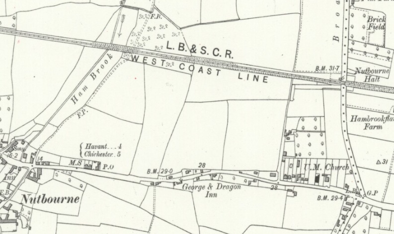
Nutbourne Station
Opened in 1906 as Nutbourne Halt. Renamed Nutbourne in 1969 (?).
Nutbourne Station map early 1900s.
Nutbourne Station early 1900s.
.jpg)
Bosham Station
Opened in 1847.
Bosham Station map early 1900s.

Bosham Station.

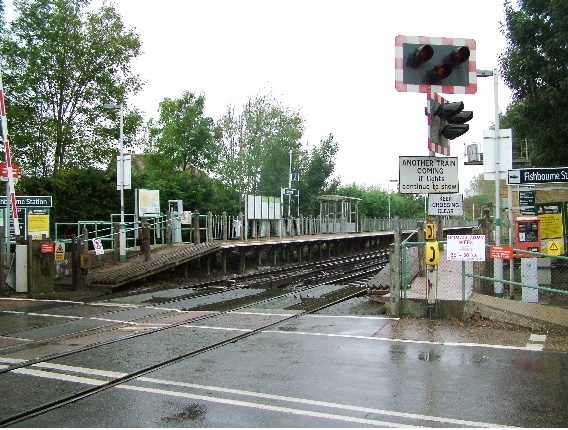
Fishbourne Station
Opened in 1906.
Fishbourne Station map early 1900s.

Fishbourne Station.
Fishbourne Junction
Fishbourne Junction was where the Havant to Brighton Line joined the Chichester and Midhurst Line which opened 1881 and operated by the LB&SCR. It was built to a very high standard with a double track loading gauge, despite only being single tracked, in case there was ever a need to increase capacity. The stations were designed by T. H. Myres, in his standardized Domestic Revival style, each formed like a large "Country House".
The passenger trains were withdrawn in 1935 but freight services remained until 1951. The freight services to Cocking and Singleton were withdrawn in 1953 but Lavant lasted until 1968. The line was cut back before Lavant station to serve gravel workings from 1972 but this was in turn withdrawn finally in 1991.
Fishbourne Junction map early 1900s.

Fishbourne Junction.

Chichester Station
Opened in 1846 and rebuilt in 1957.
Chichester Station map late 1800s.

Chichester Station.

The West Sussex Railway: This ran from Chichester Station to Selsey. It was also known as the West Sussex Railway (Tramway Section) and the Hundred of Manhood and Selsey Tramway. Further information can be found at Starzina - West Sussex Railway, and Wiki - West Sussex Railway.
Chichester Ship Canal:The Chichester Ship Canal runs from the sea at Birdham on Chichester Harbour to Chichester through two locks. The canal (originally part of the Portsmouth and Arundel Canal) was opened in 1822.
Proposals for a canal linking Chichester directly to the sea go back as least as far as 1585 and further proposals were made in the early 19th century, but none of these came to pass and as a result the first link to the sea was via a branch of the Portsmouth and Arundel Canal opened in 1822. It had been decided that the section between Chichester and Chichester Harbour, unlike the rest of the canal, would be built large enough to carry boats of 100 tons.
The Portsmouth and Arundel Canal was conceived as part of a bigger plan to provide a secure inland canal route from London to Portsmouth, but by the time the route was completed, the war with France had ended. With the reason for its construction removed, the canal was not a commercial success, and apart from the Chichester section, it had fallen into disuse by 1847. The last recorded commercial traffic on the Chichester section was in 1906. 1923 it was accepted that there would be no further traffic and the swing bridges Donnington and Birdham were replaced by fixed bridges so restricing the use of the canal. The canal survived until 1928 before being formally abandoned. In 1932 the section of the canal between Cutfield Bridge and Salterns lock was reopened to allow yachts to be berthed there.
During World War 2 the canal was converted into an anti tank obstacle as part of the preparations against a German invasion. These conversions included dismantling 4 swing bridges and building a dam above Cutfield bridge to raise the water level by 3 feet using water diverted from the River Lavant.
Further information can be found at Wiki - Chichester Canal, and Chichester Ship Canal - History, and Wiki - Portsmouth and Arundel Canal.
Chichester Ship Canal map today.

Chichester Ship Canal (Chichester Basin and Padwick Bridge) map late 1800s.

Chichester Ship Canal (Tramway Drawbridge and Poyntz Bridge Hunston) map early 1900s.

Chichester Ship Canal (Crosbie Bridge and Dudley Bridge) map late 1800s.

Chichester Ship Canal (Cutfield Bridge) map late 1800s.

Chichester Ship Canal (Casher Bridge and Egremont Bridge) map late 1800s.

Chichester Ship Canal (Salterns Lock) map.

Chichester Ship Canal - A heavily-guarded bullion shipment at Hunston.

Goodwood: Goodwood is home to a small Airfield, and both Horse Racing and Car Racing - see goodwood.com
Goodwood Horse Racecourse: In 1801 the Duke of Richmond layed out a course on that part of the Goodwood Estate known as the Harroway for officers to hold their annual races which had up until then been in nearby Petworth Park. There is also a suggestion racing was held at Goodwood in the 1700s and the course was the first to use a flag start.
Further information can be found at The Eclipse Magazine, and Getty Images.
Goodwood Horse Racecourse map late 1800s.

Goodwood Horse Racecourse from The Trundle 1930s.

Goodwood Circuit:Goodwood Circuit is a historic venue for both two- and four-wheeled motorsport. This is the racing circuit dating from 1948, not to be confused with the separate hillclimb course located at Goodwood House and first used in 1936. Because the owners did not want to modify the track with chicanes to control the increased speeds of modern racing cars the last event was in 1966. The racing circuit began life as the perimeter track of RAF Westhampnett airfield, which was constructed during World War II as a relief airfield for RAF Tangmere.
Goodwood is noted for its annual Festival of Speed - an annual hill climb held in the nearby grounds of Goodwood House and Goodwood Revival - for the types of cars and motorcycles that would have competed during the circuit's original period, historic aircraft help to complete the vintage feel where nearly everyone dresses up in vintage outfit from mods and rockers to racing drivers and just smart period clothes.
Further information can be found at Wiki - Goodwood Circuit, and Wiki - Festival of Speed, and Wiki - Goodwood Revival, and Getty Images - Car Racing, and Getty Images - Revival Festival, and Getty Images - Festival of Speed.
Goodwood Circuit map 1950s.

Goodwood Circuit.

Goodwood Revival.

Goodwood Airfield: The airfield was built during the Second World War by the Royal Air Force as a relief landing ground for nearby RAF Tangmere. The site was the former Westhampnett Farm and part of the Goodwood Estate. It was known as RAF Westhampnett.
After the war the airfield was returned to the Goodwood Estate and the perimeter track of the airfield has been used since the late 1940s for motor racing and called the Goodwood Circuit. The airfield currently has a large flying school and many historic aircraft.
Goodwood Airfield map 1950s.
Goodwood Airfield.

Tangmere Airfield: RAF Tangmere was a Royal Air Force station famous for its role in the Battle of Britain. Second World War aces wing commander Douglas Bader, and the then inexperienced Johnnie Johnson (who went on to become the highest scoring Western Allied fighter ace against the Luftwaffe) were at Tangmere in 1941.
The aerodrome was founded in 1917 for use by the Royal Flying Corps as a training base. In 1918 it was turned over to the American Air Force as a training ground, and continued as such until the end of the Great War after which the airfield was mothballed. In 1925 the station re-opened to serve the RAF's Fleet Air Arm, and went operational in 1926. In 1939 the airfield was enlarged to defend the south coast against attack by the Luftwaffe, with Tangmere's only hotel and some houses being demolished in the process. The RAF commandeered the majority of houses in the centre of the village and it was only in 1966 that the village resumed its status as a civilian community. In 1963-64 the last flying units left and the station was finally closed in 1970 and some of the land around the runways was returned to farming and housing. Tangmere Military Aviation Museum is now at the airport site.
The first and worst enemy raid on the station came on 16 August 1940 when hundreds of Stuka dive bombers and fighters crossed the English coast and attacked Tangmere. There was extensive damage to buildings and aircraft on the ground and 14 ground staff and six civilians were killed, but the station was kept in service and brought back into full operation. Throughout the war, the station was also a secret base for the Special Operations Executive who used the Westland Lysander to fly agents in and out of occupied France for the Resistance.
Tangmere Airfield map 1940s.

Tangmere Airfield 1940s.

Tangmere Airfield Control Tower 1980s.

Chichester Gravel Pits
There were gravel pits north and south of the line to the east of Chichester station.
Chichester Gravel Pits map early 1900s.


Opened in 1846 closed in 1930.
Drayton Station map early 1900s.

Drayton Station.

Woodgate Station
Opened in 1846 and closed in 1864 with the opening of the Bognor branch line. The first station to serve Bognor was situated on the main line at Woodgate Crossing, just over one mile west of the present Barnham railway station. It was opened in 1846 by the Brighton and Chichester Railway, which became the London Brighton and South Coast Railway a few weeks later. This station was renamed several times during its short life becoming Woodgate for Bognor, Woodgate, Bognor (again) and Woodgate (again) before closing in 1864.
Woodgate Station map late 1800s.

Barnham Station and Junction
Opened in 1846. Barnham is the junction station for the short branch to Bognor Regis which was opened in 1864.
Barnham Station and Junction map early 1900s.

Barnham Station and Junction 1961 and Derailment in 1962.


Fontwell Park Horse Racecourse: Alfred Day came to The Hermitage, on the north side of the Chichester to Arundel road, in 1887 to train racehorses. While researching the history of the area, he found a reference on a 1630 map to �Fontwell�. This was the name of the spring in front of his house, the only watering-hole on this major south coast route, and which the Romans had originally called �Fons�. Passing monks are said to have added the �well� part of the name. Day brought the name Fontwell back into use. By 1924 he had purchased enough land to open a racecourse at Fontwell. The hurdles track was a conventional oval shape, but the steeplechase course was designed as a figure of eight to make best use of the limited space available. The grandstand and the weighing room were built with thatched roofs.
Further information can be found at Fontwell Park History.
Fontwell Park Horse Racecourse map 1940s.

Fontwell Park Horse Racecourse.

Bognor Regis
Opened in 1864. The first station to serve Bognor was situated on the main line at Woodgate Crossing.
The site of the present station dates from the opening of the branch line to Bognor from Barnham in 1864, after several abortive projects to connect the town to the railway system in 1845, 1853 and 1855. The station suffered two disasters in the 1890s, when it was blown down in a gale in 1897, and then burned down in 1899. The present station buildings date from 1902. The station was renamed 'Bognor Regis' 1930 as the town was renamed as such having been the place of the King's (George V) recuperation from serious illness.
Bognor Regis Station map early 1900s.

Bognor Regis Station 1903 and 1964.


Photos of Bognor Regis Station.
kjs2012
picclick
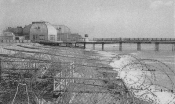
Bognor Regis Pier: Opened in 1865. A large pavilion housing arcade with shops, theatre and picture-house were added 1912.
In 1936 a three-tier landing stage was built at the sea end. The higher level was used for paddle steamers and the two lower levels for smaller vessels.
In the years of 1964-1965 severe storms caused the seaward end structure to collapse causing the total loss of the pavilion. In 1994 an application was made to demolish the remaining seaward end of the structure. In 1999 further storms caused more of the pier to be lost to the sea. In the last few years, further rough seas have caused weakening of the remaining seaward end structure, and in 2008 80-ft of the pier was removed for safety reasons.
Bognor Regis Pier map early 1900s.

Bognor Regis Pier 1920s and 1940s.


Bognor Beach scaffolding defences 1940s.

Yapton Station
Opened in 1846 closed in 1847 and re-opened in 1849, finally closed in 1864 with the opening of the Bognor branch line.
Yapton Station (site of) map late 1800s.

Yapton Station (remains of) 1930s.

Ford Station, Ford Junction, Arundel Junction and Littlehampton Junction
Opened in 1846.
Ford and Littlehampton Junctions are the junctions for the short branch to Littlehampton and the Mid Sussex Line.
Ford Station and Junctions map early 1900s.

Ford Station.

Ford Station crash 1951.
Ford Airport: The world�s most famous intruder airfield, originally opened in March 1918 for use by RAF and American squadrons prior to closing in January 1920. The site reopened for civil flying ten years later, becoming involved in early air-to-air flight refuelling experiments, and resumed military aviation connections from the end of 1937. Fleet Air Arm training units primarily employed Ford into World War Two but their base suffered extremely heavy damage and loss of life following a ferocious attack by Junkers Ju 87s on August 18 1940. As a result the RAF quickly returned and Ford gained prominence in its best known role as various intruder squadrons � notably No 23 � roamed enemy-occupied territory to attack targets at will with considerable success. Operational duties gradually altered to also include fighter-bomber sorties as the airfield became heavily involved through the vital D-Day period and beyond.
Ford was closed for military use 1958 but civil aircraft continued to employ the airfield until all flying finally ceased in 1980.
Site of Ford Airport map.

Opened in 1863 and redeveloped in 1937.
A station called Arundel & Littlehampton ??? opened in 1846 on the main Brighton�Portsmouth Line. This closed shortly after the branch line to the town itself opened in August 1863, when a west-facing connection was made at Ford Junction. In 1887, the third side of the triangle was constructed, allowing through running from the lines from Horsham and Brighton. The south junction was named Littlehampton Junction, while the eastern connection was named Arundel Junction.
Littlehampton Station map early 1900s.

Littlehampton Junction map late 1800s.

Littlehampton Junction map early 1900s.

Littlehampton Station early 1900s.

Littlehampton Sheds early 1900s.

Littlehampton Wharf 1910.

Photos of Littlehampton Station.
The Sussex Motive Power Depots
Opened in 1846 as Arundel & Littlehampton (?), closed 1914.
Lyminster Halt map early 1900s.

Lyminster Halt.
Opened in 1846, the original station was replaced by a new one in the 1860s .
Angmering Station map early 1900s.

Angmering Station pre 1860s and post 1860s.


Rustington Airfield: Operated from 1917 to 1918 under US control. The airfield in Rustington stretched from Ash Lane to Pigeon House Lane and to the north and south of Station Road. The area concerned is now known as the Sea Estate. Over a few months of intense activity Rustington aerodrome was very nearly completed but the ending of the war meant that the site never reached full operational status.
A siding off the London & Brighton and South Coast Railway was also constructed connecting to Angmering Station.
Further information can be found at "The American Aerodrome in Rustington".
Goring-by-Sea Station
Opened in 1846.
Goring-by-Sea Station map early 1900s.

Goring-by-Sea Station early 1900s.

Opened in 1937.
Durrington-on-Sea Station map mid 1900s.

Durrington-on-Sea Station.

Opened in 1889. The station was expanded by the addition of a large goods yard in 1905 which catered for the produce of the large number of market gardens in the area (in late 1800s and early 1900s Worthing was the centre of the tomato growing industry, with miles of glasshouses on either side of the town) but by 1932 part of the yard was given over to the carriage sheds which, until mid-2008, stood to the west of the station.
Historically, the station was planned to be the southern terminus of a new line running from the Midlands to the South Coast, and delivering holidaymakers to the new town of West Worthing; it was consequently built near the northern end of Grand Avenue, which runs from the station to the sea. The line was never constructed.
West Worthing Station map early 1900s and 1930s.


West Worthing Station late 1800s.

West Worthing Crossing (aka Tarring crossing) mid 1900s.

Worthing�s first railway station, built in 1845, was replaced a larger second building, with unusual gabled canopies over the platforms, in 1869. The present station, built in 1911, was to have been rebuilt in 1967 but the plan was abandoned.
Worthing Station map early 1900s.


Worthing Station late 1800s.


Worthing Station early 1900s.

Worthing Station 1930s after electrification.
Worthing Station today.

In 1896 the first moving picture show in Worthing was seen on the pier. In 1897 a steam ship began operation between Worthing Pier and the Chain Pier in Brighton.
In 1913 the pier was damaged in a storm, with only the southern end remaining, completely cut off from land. A rebuilt pier was opened in 1914. In 1933 the pier and all but the northern pavilion were destroyed by fire. In 1935 the remodelled Streamline Moderne pier was opened, and it is this that remains today.
In 1940 Worthing Pier was sectioned for fear of German invasion after the retreat at Dunkirk. A large hole was also blown in the pier to prevent it being used as a possible landing stage in the event of invasion.
Worthing Pier map late 1800s.

Worthing Pier early 1900s.

Worthing Pier 1913.

Worthing Pier mid 1900s.

Worthing Pier Today.

Worthing Defences 1940.
Opened in 1905 as Ham Bridge Halt. Renamed East Worthing Halt in 1949 and East Worthing in 1969.
East Worthing Station map 1930s.

East Worthing Station as Ham Bridge and East Worthing Halt.


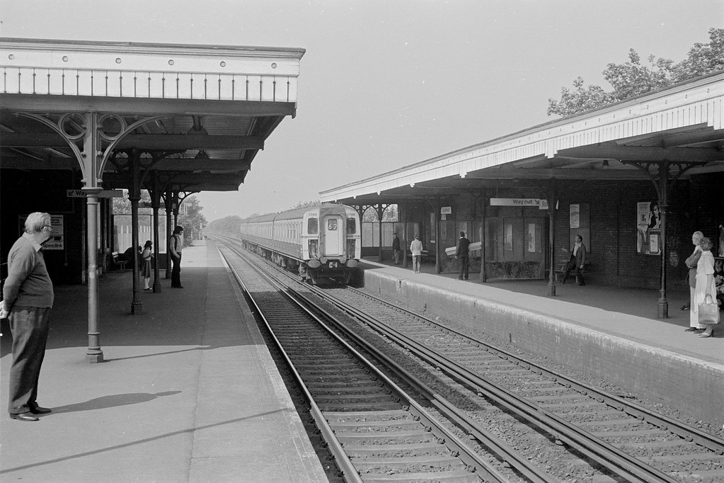
Opened in 1845. In 1912 a Carriage Works was opened at Lancing (closed in 1965), with many employees transferred from Brighton. Because of the rural situation of the new factory the railway operated a special daily train from Brighton for the workforce. This became known as the Lancing Belle which would stop at principal stations between Brighton and Lancing in the morning but on the return in the evening would only slow down enough to let the workman jump off.
Lancing Station and Carriage Works map early 1900s and 1950s.


Lancing Station.

Lancing Carriage Works.

Photos of Lancing.
Station - D Nolan
Carriage Works - Ian Nolan
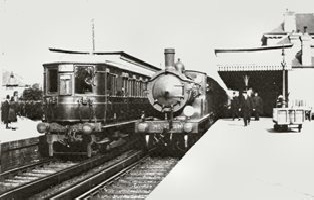
Originally called Bungalow Town Halt and opened in 1910 and closed in 1940, renamed Shoreham Airport Station in 1935. In 1930 it was the first station to serve an airport in England.
Shoreham Airport Halt map 1930s.

Shoreham Airport: Founded in 1910, Shoreham is the oldest airport in the UK and the oldest purpose-built commercial airport in the world. Opened for flights in 1911. The 1930s Art Deco terminal building is listed. In 1938 passenger air services were in operation from Shoreham Airport to Jersey, Birmingham and Liverpool.
Further information at ATC History.
Shoreham Airport map mid 1900s.
Shoreham Airport.

Shoreham Viaduct
It was not until 1845 that the River Adur was spanned with a wooden trestle bridge to carry the railway on to Worthing. The current steel bridge replaced the trestle bridge in 1893.
Shoreham Viaduct map late 1800s.

Shoreham Viaducts - wooden and steel.


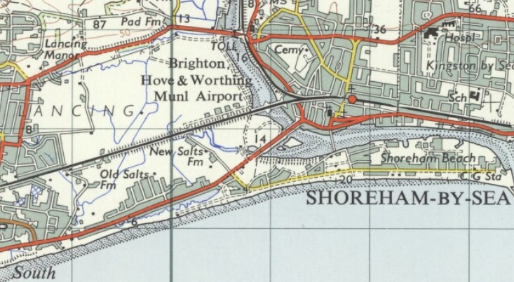
Shoreham-by-sea Station
Opened in 1840 as Shoreham, renamed Shoreham Harbour in 1906 and Shoreham-by-Sea in 1906.
The original Shoreham station was a terminus built by the London and Brighton Railway and was opened in 1840. The original building was demolished in 1845 when the Brighton and Chichester Railway opened its line to Worthing railway station. Both railways merged with others in July 1846 to become the London Brighton and South Coast Railway.
When a railway from London to the south coast was proposed the advocates of a direct line to Brighton rather than to Shoreham secured the support of Shoreham's interests by giving the branch between the two towns priority in construction over the main line from London. The branch was opened in 1840 and the main line in 1841, putting Shoreham, whence weekly packets had been sailing to Dieppe since the 1790s on the shortest and cheapest route between London and Paris. The railway company and the harbour commissioners, however, could not agree about the building of a railway port at Shoreham, and the company instead established a cross-channel port at Newhaven. The railway along the south coast was extended from Shoreham to Worthing in 1845. A single-track branch line from Shoreham to Steyning and Horsham (known as the Steyning Line or Adur Valley Line) was opened in 1861 and closed in 1966.
Shoreham-by-sea Station, Viaduct and Dorking, Horsham and Shoreham branch map late 1800s.
Shoreham-by-sea Station and Goods Yard map early 1900s.

Shoreham-by-sea Station.

Shoreham Harbour: Click here for Development of Shoreham Harbour 1760-1880.
Other railway lines in Shoreham Harbour:
Track to the 'Mystery Towers'. A railway link was laid from the dock line under the road to the western arm of Shoreham Harbour, this then ran along the bottom of the embankment, across Kingston Lane, swinging across the coast road and along the edge of the wharf, it crossed the single lock that was there then, on a movable contraption, then jointed several miles of sidings serving the works.
Click here for full report.
Diagram showing Mystery Towers.

West Pier.
Shoreham West Pier track map 1930s.

Shoreham West Pier track.

Gasworks.
Shoreham Gasworks track map early 1900s.

Filmmaking in Shoreham: Films were made using the deserted parade ground at the fort as an open-air film studio in 1914. Also part of Shoreham beach which was little more than a narrow and largely neglected shingle spit, before a visit in 1900 by the elegant international music-hall star, Marie Loftus. She was so enamoured by the peace and solitude of the area that she decided to build a holiday home there. The area soon became known as Bungalow Town, as many of Marie�s friends visited, fell in love with the place and built their own discreet single-storey holiday home away from the public gaze. Many properties were flimsily built around one or two redundant railway carriages sold off cheaply by the nearby Lancing Railway Carriage Works.
Today there are only a few railway carriages to be found in bungalow town. The whole bohemian life-style may have long gone but traces remain in the collection of houseboats in Shoreham Harbour.
Horses towing old carriages to Shoreham.


Shoreham House Boats of Today.


Kingston-by-sea Station
Opened in 1840 and closed in 1879.
Kingston-by-sea Station map late 1800s.

Kingston Wharf mid 1900s.

Southwick Station
Opened in 1840
Southwick Station map late 1800s.

Southwick Station 1970s.
Fishersgate Station
Opened in 1905 as Fishersgate Halt and renamed Fishersgate in 1969.
Fishersgate Halt map early 1900s.

Fishersgate Station.

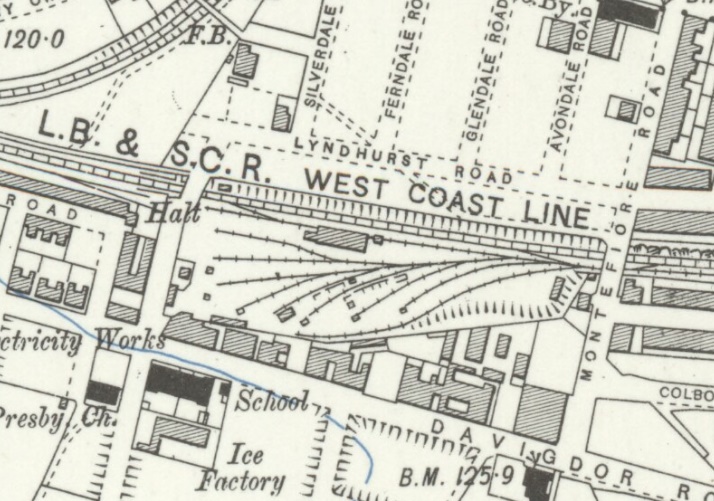
Ronuk Factory Sidings
In 1902 the Ronuk factory at Portslade was established.
Ronuk Factory Sidings map 1930s.

Ronuk Factory Sidings 1920s.

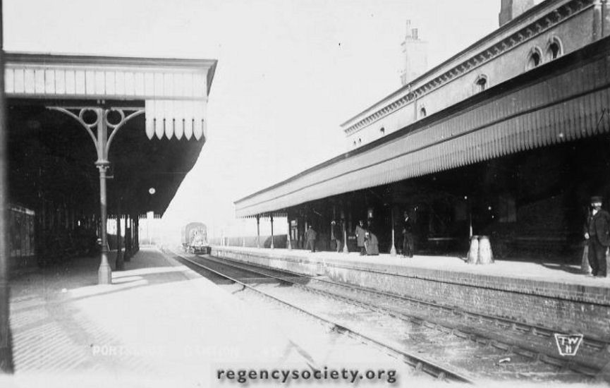
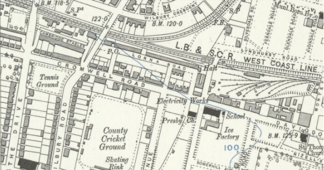
Portslade Station
The original station opened in 1840 serving Copperas Gap (as Portslade-by-Sea was once known) was located on the west side of the level crossing. It appears there was such a lack of passenger traffic that the station closed in 1847 and did not re-open for another ten years. A new station was built in 1881. The full name for he station is Portslade & West Hove.
There was a goods yard, on the west side of the level crossing, which closed in 1968.
Portslade Station and Goods Yard map early 1900s.

Portslade Diagram.

Portslade Station 1910, 1924 and Today.


Portslade - Greens Cake Sidings (west of Olive Road bridge) 1960s.

Aldrington Station/Dyke Junction Halt
Dyke Junction, where the Brighton and Dyke Railway to Devil's Dyke branched off, was opened in 1887, closed temporarily between 1917-1920 and finally closed in 1939.
Dyke Junction Halt was opened in 1905 with short wooden platforms. In 1932 new longer platforms, renamed Aldrington Halt, were constructed on an adjacent site nearer Hove to the previous platforms.
Aldrington Station/Dyke Junction Halt map early 1900s and 1930s.


Aldrington Station/Dyke Junction Halt.

Brighton and Dyke Railway
Opened in 1887, closed temporarily between 1917-1920 and finally closed in 1939.
Running from Aldrington Station/Dyke Junction Halt to The Dyke railway station.
Click here for an article on the railway.
Photos of Brighton and Dyke Railway.
Regency Society - James Gray Collection
Brighton and Dyke Railway: Route map late 1800s.

Brighton and Dyke Railway: Rowan Halt
Opened in 1933, closed in 1939.
Brighton and Dyke Railway: Rowan Halt.

Brighton and Dyke Railway: Dyke Golf Club Halt
Opened in 1891, closed temporarily between 1917-1920 and finally closed in 1939. Originally called Dyke Golf Club Platform, later changing to Halt.
Brighton and Dyke Railway: Dyke Golf Club Halt map.

Brighton and Dyke Railway: Dyke Golf Club Halt 1930s.

Brighton and Dyke Railway: The Dyke Station
Opened in 1887, closed temporarily between 1917-1920 and finally closed in 1939.
Brighton and Dyke Railway: The Dyke Station map early 1900s.

Brighton and Dyke Railway: The Dyke Station 1927.

Photos of The Dyke Station.
Disused Stations
Regency Society - James Gray Collection
Hove Station
Opened in 1865 as Cliftonville, in 1879 renamed West Brighton, in 1894 renamed Hove and West Brighton and in 1895 renamed Hove.
The original Hove railway station, situated further to the east, opened in 1840 , it closed in 1880, and was converted into the Holland Road Goods Depot. A wooden halt named Holland Road Halt was also opened a short distance to the west in 1905, this closed in 1956.
Hove (Original) Station map mid 1800s.

Hove (Cliftonville) Station map late 1800s.

Hove Station and Goods Yard map early 1900s.

Hove Station 1905.

Hove Station 1960s.

Photos of Hove Station.
Brighton Loco Works
Ian D Nolan
Holland Road Halt
Opened in 1905, closed in 1956.
Holland Road Halt and Cliftonville/Preston Park Spur map early 1900s.

Holland Road Halt.

Holland Road Halt and Sidings early 1900s.

Holland Road Goods Yard
Opened in 1880, closed in 1970s.
Holland Road Goods Yard map early 1900s.
Holland Road Goods Yard 1960s.

Cliftonville/Preston Park Spur
Opened in 1879. Cliftonville Spur or the Preston Park Spur (and known also as the Cliftonville Curve) is a short railway that links the West Coastway Line to the Brighton Main Line between Hove and Preston Park. The line was named in reference to Cliftonville station (now called Hove) which had opened in 1865.
Cliftonville/Preston Park Spur map early 1900s.
Brighton Station, Goods Station and Yard, Locomotive Depot and Railway Works
Opened in 1840, initially connecting Brighton to Shoreham-by-Sea, westwards along the coast, and shortly afterwards connecting it to London Bridge to the north (1841), and to Lewes to the east. Built by the London & Brighton Railway which in 1846 became the London Brighton and South Coast Railway.
The station site was extended for the opening of the Brighton Lewes and Hastings Railway in 1846 (which had been purchased by the L&BR in 1845). In July 1846, the L&BR merged with other railways to form the London, Brighton and South Coast Railway. Further extensions to the station occurred during the mid-19th century but only a limited number of additional platforms could be added because of the awkward sloping site. By the late 1870s the facilities were inadequate for the growing volume of traffic and so the existing platforms were lengthened to be able to accommodate two trains, and the three separate roofs were replaced by an overall roof during 1882/1883. Brighton station was listed at Grade II* in 1973.
A goods station and yard was also constructed on the eastern side of the passenger station but on a site 30 ft lower due to the sloping site, which was initially accessed from the Shoreham line by a second tunnel under the passenger station. The tunnel entrance was filled in after new tracks were laid into the goods yard, but a portion of it was converted into offices during World War II, and these were in use until the early 21st century. (A portion of the tunnel is still used by a local rifle club.) The site of the goods yard has since been redeveloped, and much of it forms the New England Quarter.
To the north of the station, on the east side of the main line, the railway constructed its locomotive and carriage works (one of the earliest railway-owned locomotive repair works), which operated from 1841 until 1911, when the carriage works was moved to Lancing and 1957 when the locomotive works closed. More than 1200 steam locomotives were constructed there.
The London and Brighton Railway opened a small locomotive shed and servicing facility to the north west of the station for locomotives on the Shoreham line, in 1840, and another in 1841, adjacent to the locomotive works for main line locomotives. A new much enlarged motive power depot opened in 1861, replacing the two existing facilities. During the early 1930s, following the electrification of the lines the steam motive power depot was rebuilt and reduced in size. It was closed in 1961, but remained in use for stabling steam locomotives until 1964, and was demolished in 1966.
After the closure of the main works, part of the workshop was used for the building of Isetta microcars between 1957 and 1964.
Pullman Cars 1928-1963: During 1896, the Pullman Car Company was assembling its cars (carriages) in Brighton Works from parts sent from America. It had moved to Brighton from Derby 1881. In later years contractors undertook the construction of Pullman stock, but the Pullman Company continued to maintain all its own stock itself. Only 4 Pullman coaches were built at the Brighton base.
A building on the up line (built in 1898), that had been used by the LBSCR for loco maintenance was vacated in 1928 and Pullman transferred its operations to the site. This building is (for the moment, at least) situated within the triangle of the Prestonville curve and the line to Hove, adjacent to Highcroft Villas and just north of the Lovers Walk Depot. These works were closed down in 1963 and Pullman maintenance work was transferred to other railway works.
Brighton Belle: The Brighton Belle was the world's only electric all-Pullman service and ran daily between London Victoria and Brighton from 1933 until 1972.
The London, Brighton and South Coast Railway (LB&SCR) began using Pullman cars in its express trains in 1875, and in 1881 they introduced the first all-Pullman train in the UK. Known as the Pullman Limited, this ran between London Victoria and Brighton via Horsham and subsequently ordinary rolling stock was added to the service. In 1888 a second all-Pullman service was instituted, using cars lit by electricity and designed by William Stroudley.
The LB&SCR was the origin of the British umber and cream Pullman livery. In 1903 R. J. Billinton changed the colour of the ordinary LB&SCR coaches to umber brown with white or cream upper panels, and in 1906 this colour scheme was also adopted by the Pullman Car Co., with the name of the car in large gilt letters on the lower panel and flanked on each side by a coloured transfer of the Pullman Company's crest.
Another all-Pullman service was introduced in 1908 under the name of the Southern Belle. Contemporary advertising by the LB&SCR claimed that this was "... the most luxurious train in the world...". In 1908 this could be experienced for a special London Victoria to Brighton day return fare of 12 shillings, a premium rate at a time when average earnings were around �1 a week. The Southern Belle was steam hauled until 1933, when electric units were introduced. In 1934 the train was renamed the Brighton Belle and it retained this title until withdrawal. A 'spare' multiple unit set was used for a Sunday Pullman service from Eastbourne, known as the Eastbourne Pullman for much of the 1950s, but this service was discontinued in 1957.
During the Second World War the service was suspended after a unit was badly damaged by aerial bombing at London Victoria; all cars were placed in safe storage at Crystal Palace (High Level) station, but the service was progressively reinstated in 1946.
The trains were refurbished and overhauled in 1955, but by 1972 the stock was old and rode poorly by contemporary standards and the service was withdrawn. Every car was preserved, in most cases to meet the ambitions of major breweries to 'bolt on' Pullman restaurants to pubs and hotels, although most were removed relatively quickly because of the high cost of maintenance and refurbishment a number were progressively acquired by the Venice Simplon Orient Express.
A campaign to return the Brighton Belle to mainline service was launched in 2009. A short train of three cars will undergo mainline proving trials in 2016, with mainline excursions with a four car unit commencing shortly afterwards. A restored fifth car will be added before the end of 2016, with the final car expected to be completed in 2017.
Further information can be found at Wikipedia, and brightonbelle.com, and this video, and the final run video.
Brighton Station map late 1800s.

Brighton Station map 1930s.

Brighton Station - New England Cutting 1800s.

Brighton Station Original Building.


Brighton Station early 1900s.


Brighton Station 1930s.

Brighton Works on top of chalk cliff 1846.

Brighton Main Shed and New Shed early 1900s.


Brighton Works Shunter.

Brighton Works - Used as a Bubble Car Factory 1950s.

Brighton Old Goods Line 2003.

Photos of Brighton Station and Works.
Brighton Loco Works
Brighton Motive Power Depots - Brighton Shed and Works
Ian Nolan - LBSC A1/A1X 0-6-0T 1960-3
Brighton Sheds - Google Images
Brighton Works - Google Images
Brighton Station - Google Images
History of Brighton Station and Works.
Brighton Loco Works
Brighton Motive Power Depots
Brighton London Road Viaduct
Built in the 1840s for the Brighton, Lewes and Hastings Railway which merged with London & Brighton Railway Company in 1846 to form the London, Brighton and South Coast Railway. The sharply curving structure has 27 arches and about 10 million bricks. It is still in constant use, and is listed at Grade II* for its historical and architectural significance.
Construction took 10 months: the structure was ready in 1846. By the 1870s, dense terraced housing surrounded the viaduct.
Second World War bombing severely damaged London Road Viaduct in 1943, despite this, a temporary repair allowed trains to start using the viaduct again within 24 hours and in less than a month the service was back to normal. The wartime reconstruction used blue brick as opposed to the original red and brown, with yellow brick dressings.
Brighton London Road (Preston Road) Viaduct map late 1800s.

Brighton London Road Viaduct 1846.
Brighton London Road Viaduct Bomb Damage 1943.

Brighton London Road Viaduct today.

Brighton London Road Station
Opened in 1877, originally to be called Ditchling Rise, a more accurate name as London Road is a little way away. It was designed by David Mocatta (the designer of Brighton Station).
Until the branch closed in 1971, trains to Kemptown diverged from the Brighton � Lewes line here. The Lewes-side platform building was demolished in the early 1980s. The station had a substantial refurbishment at the end of 2004 with some add on parts to the original building demolished.
Brighton London Road Station (with branch to Kemptown on right) map late 1800s.

Brighton London Road Station today.

Brighton Lewes Road Station
Opened in 1873 and was closed to passengers in 1933 but the line remained opened for goods trains until 1971. Despite its high cost the line never carried many passengers. Lewis Road Station was opened on 1st September 1873 and Hartington Road Halt was added on 1st January 1906. Passenger numbers failed to improve however and the new halt closed five years later. The branch closed completely during WW1 but was reopened to passengers on 19th August 1919 and to goods three years later. With strong competition from trams and busses the branches days were numbered and the inevitable came on 1st January 1933 when the line finally lost its passenger service for good. Freight traffic continued however and although the extensive goods depot which opened in 1970 never took the expected traffic away from Brighton it remained relatively busy for many years, finally closing on 26th June 1971. After closure the track was quickly lifted and the line was bought by Brighton Corporation. Kemp Town Station was demolished and the site is now occupied by the Freshfield Industrial; for a time the tunnel was used as a mushroom far and it is now used to store vehicles. Only the southern portal remains accessible within the fenced grounds of one of the industrial units. The northern portal has been demolished and the area landscaped at the back of a school playground. The short viaduct over Hartington Road was demolished in 1973 and the longer viaduct crossing Lewes Road and Melbourne Street was pulled down in 1976 with the last western section being cleared in 1983.
Brighton Lewes Road Station map early 1900s.

Brighton Lewes Road Station 1952.

Brighton Lewes Road Viaduct Demolition 1976.

Brighton Hartington Road Halt
Opened in 1906 and was closed in 1911.
Brighton Hartington Road Halt map early 1900s.

Site of Brighton Hartington Road Halt, to the left of the locomotive, 1953.

Brighton Kemp Town Station
The Kemp Town branch line (and Kemp Town Station) opened in 1869. Closed in 1933 to passenger service and to goods in 1971.The branch closed completely during WW1 but was reopened to passengers in 1919 and to goods in 1922.
Although only just over a mile in length it was a costly line to construct as, for most of its length, it ran through a tunnel or on a viaduct or embankment. The construction could never be financially justified but rivalries between the London Brighton & South Coast Railway who built the line and the London & Chatham & Dover Railway who wanted to build their own line into Kemp Town ensured that the fashionable suburb of Brighton got its own terminus.
The line took five years to build, diverging from the Brighton - Lewes line just east of Ditchling Road Tunnel. The branch curved southwards on an embankment to Lewes Road Station. Beyond the station the line was carried on a fourteen arch viaduct over Lewes Road followed by a three arch viaduct over Hartington Road to the short lived Hartington Road Halt. From there the line entered a short cutting before entering the Kemp Town Tunnel through Race Hill. Kemp Town Station itself had a single platform with room for expansion which never happened and an extensive goods yard.
Brighton Kemp Town Station map early 1900s.

Brighton Kemp Town Station mid 1900s.

Brighton Kemp Town Station 1962.

Brighton Kemp Town Station 1960s.


The Duke of Cumberland organised the first public racing at the current site in 1783 although racing had been taking place in Brighton from before 1713. Early races were contested by members of the armed forces who were garrisoned in the town. The principle meeting took place in July or August and was timed to fit with the local Whitehawk Fair, which was discontinued by the 1820s. According to legend, George IV, when still Prince of Wales, invented hurdle racing at Brighton while out riding with aristocratic friends. They found some sheep pens which they proceeded to jump.
A grandstand was erected in 1788, but burnt down in 1796, a fire blamed on a family of paupers who had been allowed to live in it. In 1805, the races were faced with severe disruption when the farmer who leased the racecourse threatened to plough it up unless he received the complimentary gift of wine he usually got each season. He was in the process of beginning to plough when he was chased off by a press gang and the races allowed to continue.
The course was home for a while to top class racing, and was attended by fashionable society, but it drifted out of fashion when the Prince and his friends ceased to attend. By 1850 the railway had arrived in Brighton, allowing greater access for Londoners, and the course began to thrive again. A new stand was built and the Brighton Cup inaugurated. Brighton's main meeting formed part of the "Sussex Fortnight" in summer - where the Glorious Goodwood festival was followed up by big meetings at Brighton and Lewes.
A new stand was built in 1965 but attendance declined as Brighton's tourist industry did, and the facility became run down.
The track takes the form of a horseshoe one and a half miles in length. This makes it one of the few British courses not to form a complete circuit, like Epsom with which Brighton is sometimes compared. It is a left-handed course, used for flat racing only. The longest race run today is 1 1/2 miles. However, the course used to extend a further half mile across the golf course towards Roedean. This made four mile races possible, starting at the winning post and going the reverse way round the track, then looping at the two mile start and returning the conventional way. Hurdle races were also formerly held at Brighton.
Further information can be found at Wiki - Brighton Racecourse, and Brighton Racecourse History.
Brighton Racecourse map late 1800s.

Brighton Racecourse 1800s.

Black Rock Lido:
In 1936 an Art Deco Lido was constructed at beach level, but this was closed in 1978 and demolished in 1979, having been run down ever since its closure during World War II.
Black Rock Lido map 1930s.

Black Rock Lido1940s.

Volk's Electric Railway
Volk's Electric Railway (VER) is a narrow gauge heritage railway that runs along a length of the seafront at Brighton. It was built by Magnus Volk, the first section being completed in 1883, and is the oldest operating electric railway in the world. Although it was preceded by Werner von Siemens's 1879 demonstration line in Berlin and by the Gross-Lichterfelde Tramway of 1881, neither line is still operational.
In 1883 Magnus Volk opened a short, 2 ft electric railway running for 1/4 mile between Swimming Arch (opposite the main entrance to Brighton Aquarium, and adjacent to the site of the future Palace Pier) and Chain Pier. In 1884 the line was extended a further 1/2 mile beyond the Chain Pier to Paston Place (now known as Halfway), and regauged to 2 ft 8 1/2 in. Following the closure of the Brighton and Rottingdean Seashore Electric Railway in 1901, Volk's original electric railway was extended from Paston Place (today's Halfway) to Black Rock.
In 1930 the line was cut back 200 yards from Palace Pier to its present terminus, still known as Aquarium. In 1935 a lido was built at Black Rock, and the line was shortened by around 200 yards to accommodate it. In 1937 a new Black Rock station was opened at the end of the shortened line. In 1940, Brighton Corporation took control of the line. Only four months later, World War II defensive preparations caused the line to close. After the war, starting in 1947, the corporation rebuilt the line. At Black Rock a new station was built to replace the 1937 building which had suffered badly during the war. The line reopened for passengers in 1948. In the late 1990s the Black Rock end of the line was temporarily shortened by 211 feet to permit a storm water storage scheme to be built in the marina area. The 1948 station was demolished and replaced by a new single platform station, which opened in 1998.
Further information can be found at Wiki - Volk's Electric Railway, and Volk's Electric Railway Association, and Google Images - Volk's Electric Railway, and videos.
Volk's Electric Railway Stations maps early 1900s.


Volk's Electric Railway 1884 and 1890.


Brighton and Rottingdean Seashore Electric Railway
The railway was a unique coastline railway in Brighton that ran through the shallow coastal waters of the English Channel between 1896 and 1901. The railway officially opened 28 November 1896, but was nearly destroyed by a storm the night of 4 December. Volk immediately set to rebuilding the railway including the Pioneer, which had been knocked on its side, and it reopened in July 1897.
Magnus Volk, its owner, designer and engineer, had already been successful with the more conventional Volk's Electric Railway, which had then not been extended east of Paston Place. Facing unfavourable geography, Volk decided to construct a line through the surf from a pier at Paston Place to one at Rottingdean. This was also home to Volk's Seaplane Station.
The railway itself consisted of two parallel 2 ft 8 1/2 in gauge tracks, billed as 18 ft gauge, the measurement between the outermost rails. The tracks were laid on concrete sleepers mortised into the bedrock. The single car used on the railway was a pier-like building which stood on four 23 ft-long legs. It was officially named Pioneer, but many called it Daddy Long-Legs. Due to regulations then in place, a qualified sea captain was on board at all times, and the car was provided with lifeboats and other safety measures.
The railway was popular, but faced difficulties. The car was slowed considerably at high tide, but Volk could never afford to improve the motors. In 1900, groynes built near the railway were found to have led to underwater scouring under the sleepers and the railway was closed for two months while this was repaired. Immediately afterward, the council decided to build a beach protection barrier, which unfortunately required Volk to divert his line around the barrier. Without funds to do so, Volk closed the railway. In 1901 the right-of-way was broken up for construction of the barrier. The track, car and other structures were sold for scrap, but some of the concrete sleepers can still be viewed at low tide. Eventually Volk's Electric Railway was extended onshore, covering a portion of the same distance; it remains in operation. A model of the railway car is on display (along with a poster for the railway) in the foyer of the Brighton Toy and Model Museum.
Further information can be found at Urban75, and Google - Brighton and Rottingdean Seashore Electric Railway, and video.
Maps of abandoned Brighton and Rottingdean Seashore Electric Railway at Brighton and Rottingdean early 1900s.


Brighton and Rottingdean Seashore Electric Railway.


Royal Suspension Chain Pier
Built in 1823 and known as the Chain Pier. Destroyed in 1896. It was primarily intended as a landing stage for packet boats to Dieppe, France, but it also featured a small number of attractions including a camera obscura.
The Chain Pier co-existed with the later West Pier, but a condition to build the Palace Pier was that the builders would dismantle the Chain Pier. They were saved this task by a storm which destroyed the already closed and decrepit pier in 1896. The remains of some of the pier's oak piles, sunk ten feet into bedrock, can still be seen at the most extreme low tides. The entrance kiosks and signal cannon of the pier are still intact, and are now used as small shops on the Palace Pier.
Further information can be found at Wiki - Royal_Suspension_Chain_Pier, and Google Images - Brighton Chain Pier.
Chain Pier map late 1800s.

Chain Pier.

West Pier
Opened in 1866 and closed in 1975 and subsequently fell into disrepair. The pier gradually collapsed during the early 21st century. Major sections collapsed in late 2002, and two fires in 2003 left little of the original structure. Subsequently, English Heritage declared it to be beyond repair. Structured demolition took place in 2010 to make way for the observation tower i360; further structural damage from storms has occurred since.
The pier was the first to be Grade I listed in Britain. Designed by architect Eugenius Birch and called his "masterpiece". It was the town's second pier, joining the Royal Suspension Chain Pier of 1823. It was extended in 1893 and a pavilion added. The 19th century bandstand was demolished between 1914 and 1916 and replaced by an eight-sided grand concert hall. The concert hall was converted into a tea room and the theatre redesigned as a restaurant in the early 1950s. A funfair was added around the same time. The pier's central decking was removed during World War II to prevent enemy landings, and in 1944 a Royal Air Force fighter hit the pier.
Further information can be found at Arthur Lloyd - Brighton West Pier, and Brighton West Pier Trust, and Wiki - West Pier, and Google Images - Brighton West Pier.
West Pier map late 1800s.

West Pier early 1900s.

West Pier fire 2003.

Palace Pier
The Brighton Marine Palace and Pier was opened in 1899; built solely as an amusement and pleasure emporium. It is generally known as Palace Pier for short but was renamed Brighton Pier in 2000 and Brighton Palace Pier in 2016. A condition to be met by its builders, in exchange for permission to build, was that the first, the Royal Suspension Chain Pier of 1823, which had fallen into a state of disrepair, was to be demolished. They were saved this task by a storm which largely destroyed the Chain Pier. The Palace Pier was listed at Grade II* in 1971.
A concert hall opened in 1901 and by 1911 this had become a theatre where summer shows were held until the 1970s. The pier was extended in 1938 but was sectioned as a war precaution two years later. In 1973 when it was decided to demolish the unused landing stage at the pier head. During the work on the landing stage and a storm in 1973, a 70-ton barge moored at the pier's landing stage broke loose and began to damage the pier head, particularly the theatre. Despite fears that the pier would be destroyed, the storm eased and the barge was removed.The damaged theatre was never used again. In 1986 the theatre was removed, on the understanding that it would be replaced, this has not happened. The present seaward end building looks fairly modern in comparison with the rest of the structure, supporting a domed amusement arcade and several fairground rides.
The Pier suffered a large fire in 2003 but the damage was limited and most of the pier was able to reopen the next day.
Further information can be found at Arthur Lloyd - Brighton Palace Pier, and Wiki - Brighton Palace Pier, and Google Images - Brighton Palace Pier.
Palace Pier map early 1900s.

Palace Pier early 1900s.

Palace Pier today.

References:
Wiki - West Coastway Line
London, Brighton and South Coast Railway
London and South Western Railway
Wiki - Midhurst Railways
Wiki - Chichester Station
Yapton History
Wiki - RAF Tangmere
Wiki - Littlehampton Station
Worthing History
Wiki - Worthing Pier
Simplon Post Cards - Worthing Pier
Wiki - Shoreham Airport
Wiki - Shoreham Station
Wiki - Steyning Line
Portslade History
Wiki - Aldrington Station
Wiki - The Dyke Railway Station
Disused Stations - Golf Club Halt
Disused Stations - The Dyke
Wiki - Hove Station
Wiki - Holland Road Halt
Wiki - Cliftonville Curve
Wiki - Brighton Station
Wiki - Brighton Railway Works
Brighton Loco Works
Grace's Guide - Brighton Works
Wiki - London Road Viaduct
Wiki - Brighton London Road Station
Wiki - Brighton Lewes Road Station
Disused Stations - Brighton Lewes Road Station
Disused Stations - Hartington Road Halt
Disused Stations - Brighton Kemp Town Station
Wiki - Brighton Belle
Wiki - Brighton and Rottingdean Seashore Electric Railway
Wiki - Volk's Electric Railway
VERA
Urban75 - Brighton Sea Railway
Simplon Post Cards - Brighton Piers
Wiki - Royal Suspension Chain Pier
Wiki - Brighton West Pier
Brighton West Pier Trust
Wiki - Brighton Palace Pier
Wiki - Brighton Racecourse
Regency Society - James Gray Collection ASLEF - Lancing
The Sussex Motive Power Depots
The Brighton Motive Power Depots
Gravelroots
Southern E Group
Sussex Industrial Archaeology Society
Airfields of Britain Conservation Trust
Air Traffic Control History
Old Maps Online